IMAGES TAKEN NEAR TO
Manorsfield Road, BICESTER, OX26 6LJ
Introduction
This page details the photographs taken nearby to Manorsfield Road, OX26 6LJ by members of the Geograph project.
The Geograph project started in 2005 with the aim of publishing, organising and preserving representative images for every square kilometre of Great Britain, Ireland and the Isle of Man.

There are currently over 7.5m images from over14,400 individuals and you can help contribute to the project by visiting https://www.geograph.org.uk
Image Map
Images are licensed for reuse under creativecommons.org/licenses/by-sa/2.0
Notes
- Clicking on the map will re-center to the selected point.
- The higher the marker number, the further away the image location is from the centre of the postcode.
Image Listing (345 Images Found)
Images are licensed for reuse under creativecommons.org/licenses/by-sa/2.0
Image
Details
Distance
1
Sobell House Hospice charity shop, Bicester
Viewed across Market Square. Text on the window shows Your Local Hospice Caring For Local People.
Image: © Jaggery
Taken: 9 Jul 2015
0.01 miles
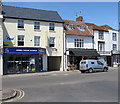
2
The Market Square, Bicester
This is outside what is now 20 Market Square, Bicester OX26 6AD
Image: © Antony Ewart Smith
Taken: 13 Oct 1954
0.02 miles
3
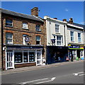
Finders Keepers, Bicester
Property letting agents at 24 Market Square. Also in view are a William Hill betting shop and a McColl's convenience store.
Image: © Jaggery
Taken: 9 Jul 2015
0.02 miles
4
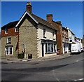
Bicester Dry Cleaners
At 25 Market Square, Bicester, on the corner of Manorsfield Road.
Image: © Jaggery
Taken: 9 Jul 2015
0.03 miles
5
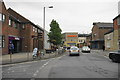
Manorsfield Road, Bicester
This is route traffic has to take through the town since Sheep Street was pedestrianised. It is interesting to see a new Sainsbury's as this town was once famous for its Tesco monopoly.
Image: © Bill Boaden
Taken: 26 Jun 2015
0.03 miles
6
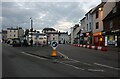
Market Square, Bicester
This is the original town centre
Image: © David Howard
Taken: 11 Oct 2020
0.04 miles
7
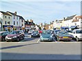
Bicester, Market Square
Leading from Sheep Street to the parish church (in the distance); seems to be triangular rather than square, and now devoted to car parking.
Image: © Mike Faherty
Taken: 1 Oct 2011
0.04 miles
8
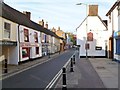
Bicester, Causeway
A pleasant town-centre street leading from Market Square to the parish church; differing facades and finishes, with small businesses.
Image: © Mike Faherty
Taken: 1 Oct 2011
0.04 miles
9
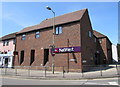
NatWest, Bicester
The Causeway side of the bank branch on the corner of Manorsfield Road.
Image: © Jaggery
Taken: 9 Jul 2015
0.04 miles
10
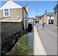
Drainage channel, Chapel Street, Bicester
On the west side of Chapel Street. The Causeway junction is ahead.
Image: © Jaggery
Taken: 9 Jul 2015
0.04 miles