IMAGES TAKEN NEAR TO
Hunt Close, BICESTER, OX26 6HX
Introduction
This page details the photographs taken nearby to Hunt Close, OX26 6HX by members of the Geograph project.
The Geograph project started in 2005 with the aim of publishing, organising and preserving representative images for every square kilometre of Great Britain, Ireland and the Isle of Man.

There are currently over 7.5m images from over14,400 individuals and you can help contribute to the project by visiting https://www.geograph.org.uk
Image Map
Images are licensed for reuse under creativecommons.org/licenses/by-sa/2.0
Notes
- Clicking on the map will re-center to the selected point.
- The higher the marker number, the further away the image location is from the centre of the postcode.
Image Listing (324 Images Found)
Images are licensed for reuse under creativecommons.org/licenses/by-sa/2.0
Image
Details
Distance
1
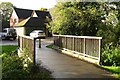
Footbridge over the River Bure
The bridge leads to Hunt Close.
Image: © Steve Daniels
Taken: 28 Oct 2013
0.02 miles
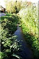
2
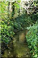
The River Bure in Bicester
The River Bure flows into the River Ray.
Image: © Steve Daniels
Taken: 28 Oct 2013
0.03 miles
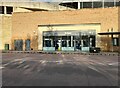
3
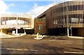
Entrance to the car park
The car park is to the new Pioneer Square complex.
Image: © Steve Daniels
Taken: 28 Oct 2013
0.05 miles
5
The River Bure by Hunts Close
The River Bure flows into the River Ray.
Image: © Steve Daniels
Taken: 28 Oct 2013
0.06 miles
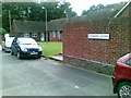
6
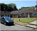
Dunkins Close, Bicester
Bungalows set back from the corner of Manorsfield Road and St John's Street.
Image: © Jaggery
Taken: 9 Jul 2015
0.06 miles
7
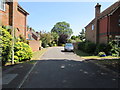
Queens Court, Bicester
Cul-de-sac on the east side of Queens Avenue.
Image: © Jaggery
Taken: 9 Jul 2015
0.06 miles
8
Public toilets at Pioneer Square, Bicester
Image: © David Howard
Taken: 17 Oct 2021
0.07 miles
9
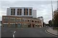
Travelodge on St John's Street, Bicester
Image: © David Howard
Taken: 11 Oct 2020
0.07 miles
10
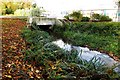
Hunts Close crosses the River Bure
The River Bure flows into the River Ray.
Image: © Steve Daniels
Taken: 28 Oct 2013
0.08 miles