IMAGES TAKEN NEAR TO
London Road, BICESTER, OX26 6HG
Introduction
This page details the photographs taken nearby to London Road, OX26 6HG by members of the Geograph project.
The Geograph project started in 2005 with the aim of publishing, organising and preserving representative images for every square kilometre of Great Britain, Ireland and the Isle of Man.

There are currently over 7.5m images from over14,400 individuals and you can help contribute to the project by visiting https://www.geograph.org.uk
Image Map
Images are licensed for reuse under creativecommons.org/licenses/by-sa/2.0
Notes
- Clicking on the map will re-center to the selected point.
- The higher the marker number, the further away the image location is from the centre of the postcode.
Image Listing (23 Images Found)
Images are licensed for reuse under creativecommons.org/licenses/by-sa/2.0
Image
Details
Distance
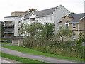
3
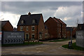
Stratton Park, Bicester
A lot of new development was going on south of Bicester town centre. This is one of the smaller sites.
Image: © Robert Eva
Taken: 23 Mar 2017
0.13 miles
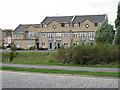
4
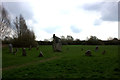
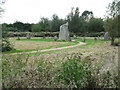
Stone circle, Bicester
Nothing on the map about an ancient monument so I suspect this is something quite recent although I was not able to find out any more information about it.
Image: © Robert Eva
Taken: 23 Mar 2017
0.16 miles
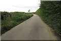
5
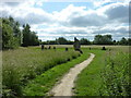
Bicester Footpath off London Road
Image: © Malcolm Sandilands
Taken: 16 Jun 2010
0.16 miles
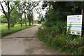
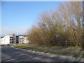
6

Landscaped roundabout on London Road, Bicester
Image: © David Howard
Taken: 1 Aug 2021
0.19 miles
8
Stone circle on Mallards Way at entrance to estate from London Road
Image: © Jon S
Taken: 26 Sep 2005
0.19 miles