IMAGES TAKEN NEAR TO
Andover Close, BICESTER, OX26 4YE
Introduction
This page details the photographs taken nearby to Andover Close, OX26 4YE by members of the Geograph project.
The Geograph project started in 2005 with the aim of publishing, organising and preserving representative images for every square kilometre of Great Britain, Ireland and the Isle of Man.

There are currently over 7.5m images from over14,400 individuals and you can help contribute to the project by visiting https://www.geograph.org.uk
Image Map
Images are licensed for reuse under creativecommons.org/licenses/by-sa/2.0
Notes
- Clicking on the map will re-center to the selected point.
- The higher the marker number, the further away the image location is from the centre of the postcode.
Image Listing (3 Images Found)
Images are licensed for reuse under creativecommons.org/licenses/by-sa/2.0
Image
Details
Distance
2
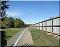
Cycleway and Fence
A cycleway runs beside the busy Bicester by-pass along a quieter route on what looks like a pre by-pass former local road. The other side of the fence appears here Image
Image: © Des Blenkinsopp
Taken: 14 Sep 2019
0.23 miles
3
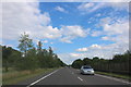
Skimmingdish Lane, Bicester
The fence on the right hides a new housing estate
Image: © David Howard
Taken: 8 Jun 2019
0.23 miles