IMAGES TAKEN NEAR TO
Hertford Close, BICESTER, OX26 4UY
Introduction
This page details the photographs taken nearby to Hertford Close, OX26 4UY by members of the Geograph project.
The Geograph project started in 2005 with the aim of publishing, organising and preserving representative images for every square kilometre of Great Britain, Ireland and the Isle of Man.

There are currently over 7.5m images from over14,400 individuals and you can help contribute to the project by visiting https://www.geograph.org.uk
Image Map
Images are licensed for reuse under creativecommons.org/licenses/by-sa/2.0
Notes
- Clicking on the map will re-center to the selected point.
- The higher the marker number, the further away the image location is from the centre of the postcode.
Image Listing (51 Images Found)
Images are licensed for reuse under creativecommons.org/licenses/by-sa/2.0
Image
Details
Distance
1
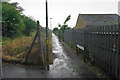
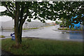
Town Walk North
Part of a small network of paths which cross the barrier created by the railway. To the left is Town Walk West which goes under the railway.
Image: © Bill Boaden
Taken: 26 Jun 2015
0.05 miles
2
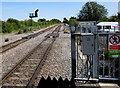
Chiltern Main Line ESE from Bicester North railway station
From platform 1, looking along the Chiltern Main Line towards London Marylebone, 89km (55 miles) away.
Image: © Jaggery
Taken: 9 Jul 2015
0.06 miles
4
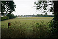
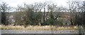
Keble Road Playing Fields
A recreation ground is at this end, while there are more dedicated sports facilities at the other end. It is viewed here in rain.
Image: © Bill Boaden
Taken: 26 Jun 2015
0.07 miles
5
Murdock Road, Bicester
An industrial part of Bicester viewed in the rain.
Image: © Bill Boaden
Taken: 26 Jun 2015
0.07 miles
7
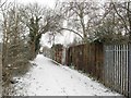
'Town Walk' Foot/Cycle Path, Bicester
Another view of the combined foot and cycle path connecting north Bicester to the Town Centre. This time looking SW towards Withington Road and the town centre.
Image: © Kurt C
Taken: 2 Feb 2009
0.09 miles
8
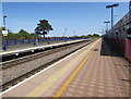
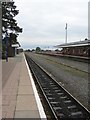
Bicester North railway station
Viewed along platform 1. The edge of a 2-level car park is on the right.
Bicester North is on the Chiltern Main Line. Service are operated by Chiltern Railways -
south to London Marylebone (ahead), north to Banbury, Stratford-upon-Avon and Birmingham Snow Hill.
Image: © Jaggery
Taken: 9 Jul 2015
0.10 miles
9
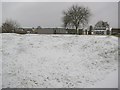
Longfields Primary School, Bicester
This picture shows a snowy scene of my former primary school! Located to the side of the main railway embankment in Bicester, Longfields School is in a pleasant area next to a main walkway which leads to the town centre. This school once owned a large double field plot of land, which I can remember playing in back in the 1980's! Some modern housing has since been developed within part of it, just visible in the background.
Image: © Kurt C
Taken: 2 Feb 2009
0.10 miles
10
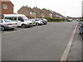
Keble Road, Bicester
Facing N up Keble Road. The junction with Churchill Road can be seen in the distance.
Image: © Kurt C
Taken: 26 Jul 2009
0.11 miles