IMAGES TAKEN NEAR TO
Churchill Road, BICESTER, OX26 4TR
Introduction
This page details the photographs taken nearby to Churchill Road, OX26 4TR by members of the Geograph project.
The Geograph project started in 2005 with the aim of publishing, organising and preserving representative images for every square kilometre of Great Britain, Ireland and the Isle of Man.

There are currently over 7.5m images from over14,400 individuals and you can help contribute to the project by visiting https://www.geograph.org.uk
Image Map
Images are licensed for reuse under creativecommons.org/licenses/by-sa/2.0
Notes
- Clicking on the map will re-center to the selected point.
- The higher the marker number, the further away the image location is from the centre of the postcode.
Image Listing (15 Images Found)
Images are licensed for reuse under creativecommons.org/licenses/by-sa/2.0
Image
Details
Distance
1
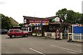
The White Horse on Churchill Road
The White Horse is a former Morrells pub.
Image: © Steve Daniels
Taken: 1 Jul 2014
0.03 miles
2
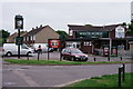
Bicester
The White Horse, located at the junction of Churchill Road and Bassett Avenue.
It would appear that a World Cup is imminent and, optimistically, will continue until 15th July.
Image: © Peter Trimming
Taken: 5 Jun 2018
0.03 miles
3
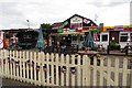
The White Horse on Bassett Avenue
The White Horse is a former Morrells pub.
Image: © Steve Daniels
Taken: 1 Jul 2014
0.04 miles
4
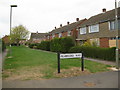
Pembroke Way, Bicester
Facing NW and looking down Pembroke Way from Keble Road. A narrow residential area joining Ruskin Walk.
Image: © Kurt C
Taken: 26 Jul 2009
0.12 miles
5
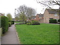
Ruskin Walk, Bicester
Facing SW and looking down this residential areas 'avenue'. Plenty of pleasant greenery in this part of Bicester.
Image: © Kurt C
Taken: 26 Jul 2009
0.13 miles
6
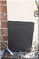
Benchmark on 'Lawn Farm', Buckingham Road
Ordnance Survey cut mark benchmark described on the Bench Mark Database at http://www.bench-marks.org.uk/bm33954
Image: © Roger Templeman
Taken: 9 Jun 2014
0.15 miles
7
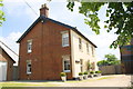
'Lawn Farm', #238 Buckingham Road
There is an OS benchmark Image on the black bottom of the right hand corner of the house
Image: © Roger Templeman
Taken: 9 Jun 2014
0.15 miles
8
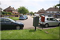
Junction of Buckingham Road and Buckingham Crescent
Image: © Roger Templeman
Taken: 9 Jun 2014
0.16 miles
9
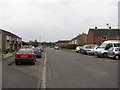
Keble Road, Bicester
Facing S towards Balliol Road and Bicester North Rail Station. This is a very flat residential area.
Image: © Kurt C
Taken: 26 Jul 2009
0.16 miles
10
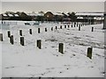
Playground at Keble Road, Bicester
A snowy scene at the playground on Keble Road. The 'playfield' beyond is actually a small football pitch. Sadly, this playground is often littered and vandalised. It used to be a much more significant playground in the 1980's, with large slides, swings, and a giant 'spider' climbing frame! Just to the right of the picture, is the modern day 'community centre'. Again, back in the 1980's, a larger more significant community centre building stood 30ft high, and hosted a variety of local events, including day nursery for young children. In the far background, the start of the industrial estate begins, spreading easterly.
Image: © Kurt C
Taken: 5 Feb 2009
0.17 miles