IMAGES TAKEN NEAR TO
Keble Road, BICESTER, OX26 4TP
Introduction
This page details the photographs taken nearby to Keble Road, OX26 4TP by members of the Geograph project.
The Geograph project started in 2005 with the aim of publishing, organising and preserving representative images for every square kilometre of Great Britain, Ireland and the Isle of Man.

There are currently over 7.5m images from over14,400 individuals and you can help contribute to the project by visiting https://www.geograph.org.uk
Image Map
Images are licensed for reuse under creativecommons.org/licenses/by-sa/2.0
Notes
- Clicking on the map will re-center to the selected point.
- The higher the marker number, the further away the image location is from the centre of the postcode.
Image Listing (58 Images Found)
Images are licensed for reuse under creativecommons.org/licenses/by-sa/2.0
Image
Details
Distance
1
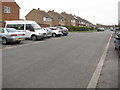
Keble Road, Bicester
Facing N up Keble Road. The junction with Churchill Road can be seen in the distance.
Image: © Kurt C
Taken: 26 Jul 2009
0.02 miles
2
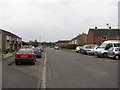
Keble Road, Bicester
Facing S towards Balliol Road and Bicester North Rail Station. This is a very flat residential area.
Image: © Kurt C
Taken: 26 Jul 2009
0.02 miles
3
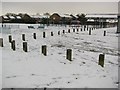
Playground at Keble Road, Bicester
A snowy scene at the playground on Keble Road. The 'playfield' beyond is actually a small football pitch. Sadly, this playground is often littered and vandalised. It used to be a much more significant playground in the 1980's, with large slides, swings, and a giant 'spider' climbing frame! Just to the right of the picture, is the modern day 'community centre'. Again, back in the 1980's, a larger more significant community centre building stood 30ft high, and hosted a variety of local events, including day nursery for young children. In the far background, the start of the industrial estate begins, spreading easterly.
Image: © Kurt C
Taken: 5 Feb 2009
0.03 miles
4
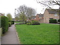
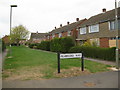
Ruskin Walk, Bicester
Facing SW and looking down this residential areas 'avenue'. Plenty of pleasant greenery in this part of Bicester.
Image: © Kurt C
Taken: 26 Jul 2009
0.03 miles
5
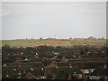
East Bicester & Poundon Hill (from rail station)
A long distance shot taken from Bicester North Station, looking over Eastern Bicester and beyond. The famous radio mast at Poundon Hill is clearly visible. From the Station footbridge, good views in all directions over Bicester are clearly seen!
Image: © Kurt C
Taken: 1 Mar 2009
0.05 miles
6
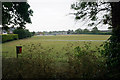
Keble Road Playing Fields
A recreation ground is at this end, while there are more dedicated sports facilities at the other end. It is viewed here in rain.
Image: © Bill Boaden
Taken: 26 Jun 2015
0.10 miles
7
Pembroke Way, Bicester
Facing NW and looking down Pembroke Way from Keble Road. A narrow residential area joining Ruskin Walk.
Image: © Kurt C
Taken: 26 Jul 2009
0.12 miles
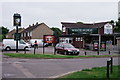
8
The White Horse on Bassett Avenue
The White Horse is a former Morrells pub.
Image: © Steve Daniels
Taken: 1 Jul 2014
0.13 miles
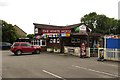
9
Bicester
The White Horse, located at the junction of Churchill Road and Bassett Avenue.
It would appear that a World Cup is imminent and, optimistically, will continue until 15th July.
Image: © Peter Trimming
Taken: 5 Jun 2018
0.14 miles
10
The White Horse on Churchill Road
The White Horse is a former Morrells pub.
Image: © Steve Daniels
Taken: 1 Jul 2014
0.14 miles