IMAGES TAKEN NEAR TO
Buckingham Crescent, BICESTER, OX26 4HD
Introduction
This page details the photographs taken nearby to Buckingham Crescent, OX26 4HD by members of the Geograph project.
The Geograph project started in 2005 with the aim of publishing, organising and preserving representative images for every square kilometre of Great Britain, Ireland and the Isle of Man.

There are currently over 7.5m images from over14,400 individuals and you can help contribute to the project by visiting https://www.geograph.org.uk
Image Map
Images are licensed for reuse under creativecommons.org/licenses/by-sa/2.0
Notes
- Clicking on the map will re-center to the selected point.
- The higher the marker number, the further away the image location is from the centre of the postcode.
Image Listing (68 Images Found)
Images are licensed for reuse under creativecommons.org/licenses/by-sa/2.0
Image
Details
Distance
1
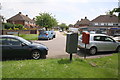
Junction of Buckingham Road and Buckingham Crescent
Image: © Roger Templeman
Taken: 9 Jun 2014
0.04 miles
2
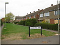
Pembroke Way, Bicester
Facing NW and looking down Pembroke Way from Keble Road. A narrow residential area joining Ruskin Walk.
Image: © Kurt C
Taken: 26 Jul 2009
0.07 miles
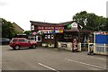
4
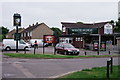
Bicester
The White Horse, located at the junction of Churchill Road and Bassett Avenue.
It would appear that a World Cup is imminent and, optimistically, will continue until 15th July.
Image: © Peter Trimming
Taken: 5 Jun 2018
0.11 miles
5
The White Horse on Churchill Road
The White Horse is a former Morrells pub.
Image: © Steve Daniels
Taken: 1 Jul 2014
0.11 miles
6
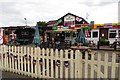
The White Horse on Bassett Avenue
The White Horse is a former Morrells pub.
Image: © Steve Daniels
Taken: 1 Jul 2014
0.11 miles
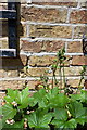
7
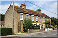
Hill View terrace, Buckingham Road
There is an OS benchmark Image on the front of the near end house to the right of the trellis
Image: © Roger Templeman
Taken: 9 Jun 2014
0.12 miles
8
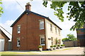
'Lawn Farm', #238 Buckingham Road
There is an OS benchmark Image on the black bottom of the right hand corner of the house
Image: © Roger Templeman
Taken: 9 Jun 2014
0.13 miles
9
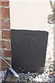
Benchmark on 'Lawn Farm', Buckingham Road
Ordnance Survey cut mark benchmark described on the Bench Mark Database at http://www.bench-marks.org.uk/bm33954
Image: © Roger Templeman
Taken: 9 Jun 2014
0.13 miles
10
Benchmark on #1 Hill View
Ordnance Survey cut mark benchmark described on the Bench Mark Database at http://www.bench-marks.org.uk/bm33955
Image: © Roger Templeman
Taken: 9 Jun 2014
0.13 miles