IMAGES TAKEN NEAR TO
Telford Road, BICESTER, OX26 4AA
Introduction
This page details the photographs taken nearby to Telford Road, OX26 4AA by members of the Geograph project.
The Geograph project started in 2005 with the aim of publishing, organising and preserving representative images for every square kilometre of Great Britain, Ireland and the Isle of Man.

There are currently over 7.5m images from over14,400 individuals and you can help contribute to the project by visiting https://www.geograph.org.uk
Image Map
Images are licensed for reuse under creativecommons.org/licenses/by-sa/2.0
Notes
- Clicking on the map will re-center to the selected point.
- The higher the marker number, the further away the image location is from the centre of the postcode.
Image Listing (22 Images Found)
Images are licensed for reuse under creativecommons.org/licenses/by-sa/2.0
Image
Details
Distance
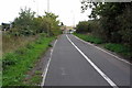
3
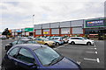
Launton Road Retail Park
Sited in a predominantly industrial area of Bicester.
Image: © Bill Boaden
Taken: 26 Jun 2015
0.12 miles
4

An array of recycling bins
Situated in the corner of Launton Road Retail Park car park.
Image: © Bill Boaden
Taken: 26 Jun 2015
0.15 miles
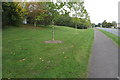
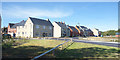
5
Benson Close, Bicester 1
Modern housing on the eastern edge of town.
Image: © Jonathan Billinger
Taken: 1 Oct 2008
0.16 miles
7
Benson Close, Bicester 2
Modern housing on the eastern edge of town.
Image: © Jonathan Billinger
Taken: 1 Oct 2008
0.17 miles
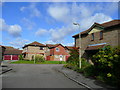
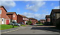
9
Vulcan View, Bicester
New housing on the edge of Bicester.
Image: © Des Blenkinsopp
Taken: 14 Sep 2019
0.20 miles
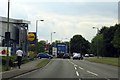
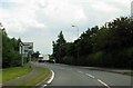
10
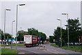
Bicester
Junction of Launton Road with Churchill Road.
Image: © Peter Trimming
Taken: 5 Jun 2018
0.22 miles