IMAGES TAKEN NEAR TO
Fluellen Place, BICESTER, OX26 3ZE
Introduction
This page details the photographs taken nearby to Fluellen Place, OX26 3ZE by members of the Geograph project.
The Geograph project started in 2005 with the aim of publishing, organising and preserving representative images for every square kilometre of Great Britain, Ireland and the Isle of Man.

There are currently over 7.5m images from over14,400 individuals and you can help contribute to the project by visiting https://www.geograph.org.uk
Image Map
Images are licensed for reuse under creativecommons.org/licenses/by-sa/2.0
Notes
- Clicking on the map will re-center to the selected point.
- The higher the marker number, the further away the image location is from the centre of the postcode.
Image Listing (17 Images Found)
Images are licensed for reuse under creativecommons.org/licenses/by-sa/2.0
Image
Details
Distance
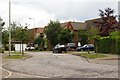
1
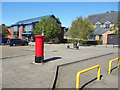
Plaza in front of Emmanuel Church
The building opposite is a church, although I mistook it for a cafe. There's a coffee shop type board outside and a nice coffee shop inside, but it's all part of the Emmanuel Church.
Very good cake.
Image: © Des Blenkinsopp
Taken: 14 Sep 2019
0.12 miles
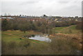
7
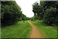
Path along the River Bure
The path runs into Bicester.
Image: © Steve Daniels
Taken: 1 Jul 2014
0.21 miles
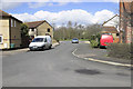
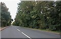
8
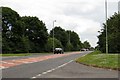
The A4095 round Bicester
The A4095 runs round the north and west perimeter of Bicester.
Image: © Steve Daniels
Taken: 1 Jul 2014
0.22 miles
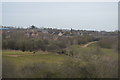
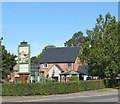
10
Bure Park Nature Reserve
http://www.lnr.naturalengland.org.uk/Special/lnr/lnr_details.asp?C=33&N=&ID=1288
Image: © N Chadwick
Taken: 23 Dec 2012
0.22 miles