IMAGES TAKEN NEAR TO
Sallow Close, BICESTER, OX26 3YP
Introduction
This page details the photographs taken nearby to Sallow Close, OX26 3YP by members of the Geograph project.
The Geograph project started in 2005 with the aim of publishing, organising and preserving representative images for every square kilometre of Great Britain, Ireland and the Isle of Man.

There are currently over 7.5m images from over14,400 individuals and you can help contribute to the project by visiting https://www.geograph.org.uk
Image Map
Images are licensed for reuse under creativecommons.org/licenses/by-sa/2.0
Notes
- Clicking on the map will re-center to the selected point.
- The higher the marker number, the further away the image location is from the centre of the postcode.
Image Listing (13 Images Found)
Images are licensed for reuse under creativecommons.org/licenses/by-sa/2.0
Image
Details
Distance
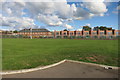
2
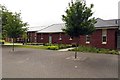
Cottages in the Garden Quarter
The former military barracks in Caversfield are being converted to luxury apartments and cottages.
Image: © Steve Daniels
Taken: 1 Jul 2014
0.18 miles
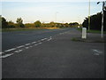
3
Fringford Road Junction
Fringford Road junction with Southwold Lane
Image: © Shaun Ferguson
Taken: 3 Jul 2019
0.19 miles
4
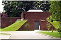
The Bunker in the Garden Quarter
The former military barracks in Caversfield are being converted to luxury apartments and cottages.
Image: © Steve Daniels
Taken: 1 Jul 2014
0.19 miles
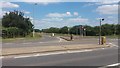
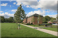
5
Former Military Buildings, Skimmingdish Lane
Part of an old MOD estate which is being redeveloped.
Image: © Des Blenkinsopp
Taken: 12 Sep 2015
0.20 miles
6
The Garden Quarter 2
Part of an estate of former military housing which has been smartened up.
Image: © Des Blenkinsopp
Taken: 12 Sep 2015
0.21 miles
7
The Sergeants Quarters in the Garden Quarter
The former military barracks in Caversfield are being converted to luxury apartments and cottages.
Image: © Steve Daniels
Taken: 1 Jul 2014
0.22 miles
9
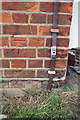
Benchmark on Building 16 of the Garden Quarter development
Ordnance Survey cut mark benchmark described on the Bench Mark Database at http://www.bench-marks.org.uk/bm33949
Image: © Roger Templeman
Taken: 9 Jun 2014
0.24 miles
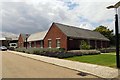
10
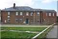
Building 16 of The Garden Quarter development, Skimmingdish Lane
There is an OS benchmark Image on the front of the building at the right hand corner
Image: © Roger Templeman
Taken: 9 Jun 2014
0.24 miles