IMAGES TAKEN NEAR TO
Primrose Drive, BICESTER, OX26 3WP
Introduction
This page details the photographs taken nearby to Primrose Drive, OX26 3WP by members of the Geograph project.
The Geograph project started in 2005 with the aim of publishing, organising and preserving representative images for every square kilometre of Great Britain, Ireland and the Isle of Man.

There are currently over 7.5m images from over14,400 individuals and you can help contribute to the project by visiting https://www.geograph.org.uk
Image Map
Images are licensed for reuse under creativecommons.org/licenses/by-sa/2.0
Notes
- Clicking on the map will re-center to the selected point.
- The higher the marker number, the further away the image location is from the centre of the postcode.
Image Listing (21 Images Found)
Images are licensed for reuse under creativecommons.org/licenses/by-sa/2.0
Image
Details
Distance
1
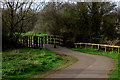
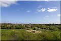
Bure Park (actual Park), Bicester
This picture was taken from the very edge of Bure Park, the actual 'park' which was formerly open farmland back in the 1980's, rather than the adjacent residential estate of the same name! Here we also see the Chiltern Railway that splits Bicester in two. The train seen is heading left (East) into Bicester North Station. A popular for local folk to walk dogs!
Image: © Kurt C
Taken: 9 Apr 2007
0.03 miles
3
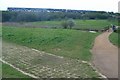
Bure Park Nature Reserve
A nature park in Bicester. http://www.lnr.naturalengland.org.uk/Special/lnr/lnr_details.asp?C=0&N=&ID=1288
Image: © David P Howard
Taken: 13 Apr 2014
0.09 miles
4
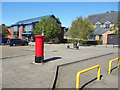
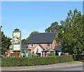
Plaza in front of Emmanuel Church
The building opposite is a church, although I mistook it for a cafe. There's a coffee shop type board outside and a nice coffee shop inside, but it's all part of the Emmanuel Church.
Very good cake.
Image: © Des Blenkinsopp
Taken: 14 Sep 2019
0.10 miles
5
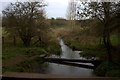
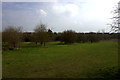
Bure Park nature reserve stream
This is taken from the path by the railway embankment. At this point the stream goes under the embankment.
Image: © Robert Eva
Taken: 23 Mar 2017
0.12 miles
7
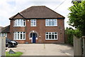
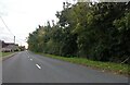
'Thorner', Banbury Road
There is an OS benchmark Image on the bricks to the right of the doorway
Image: © Roger Templeman
Taken: 9 Jun 2014
0.13 miles
8

Benchmark on 'Thorner', Banbury Road
Ordnance Survey cut mark benchmark described on the Bench Mark Database at http://www.bench-marks.org.uk/bm33945
Image: © Roger Templeman
Taken: 9 Jun 2014
0.13 miles