IMAGES TAKEN NEAR TO
Holm Way, BICESTER, OX26 3UU
Introduction
This page details the photographs taken nearby to Holm Way, OX26 3UU by members of the Geograph project.
The Geograph project started in 2005 with the aim of publishing, organising and preserving representative images for every square kilometre of Great Britain, Ireland and the Isle of Man.

There are currently over 7.5m images from over14,400 individuals and you can help contribute to the project by visiting https://www.geograph.org.uk
Image Map
Images are licensed for reuse under creativecommons.org/licenses/by-sa/2.0
Notes
- Clicking on the map will re-center to the selected point.
- The higher the marker number, the further away the image location is from the centre of the postcode.
Image Listing (7 Images Found)
Images are licensed for reuse under creativecommons.org/licenses/by-sa/2.0
Image
Details
Distance
1
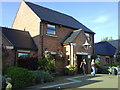
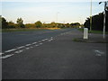
Lime Crescent, Bicester
At the heart of a maze of winding residential streets carefully laid out so there are no short cuts to anywhere for traffic.
Image: © Des Blenkinsopp
Taken: 14 Sep 2019
0.11 miles
2
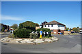
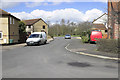
Lime Crescent Roundabout
In amongst the maze of short residential streets which makes up this area.
Image: © Des Blenkinsopp
Taken: 14 Sep 2019
0.15 miles