IMAGES TAKEN NEAR TO
Woodfield Road, BICESTER, OX26 3HN
Introduction
This page details the photographs taken nearby to Woodfield Road, OX26 3HN by members of the Geograph project.
The Geograph project started in 2005 with the aim of publishing, organising and preserving representative images for every square kilometre of Great Britain, Ireland and the Isle of Man.

There are currently over 7.5m images from over14,400 individuals and you can help contribute to the project by visiting https://www.geograph.org.uk
Image Map
Images are licensed for reuse under creativecommons.org/licenses/by-sa/2.0
Notes
- Clicking on the map will re-center to the selected point.
- The higher the marker number, the further away the image location is from the centre of the postcode.
Image Listing (76 Images Found)
Images are licensed for reuse under creativecommons.org/licenses/by-sa/2.0
Image
Details
Distance
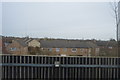
1
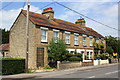
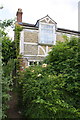
Hill View terrace, Buckingham Road
There is an OS benchmark Image on the front of the near end house to the right of the trellis
Image: © Roger Templeman
Taken: 9 Jun 2014
0.06 miles
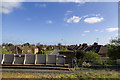
2
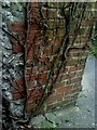
Benchmark on #1 Hill View
Ordnance Survey cut mark benchmark described on the Bench Mark Database at http://www.bench-marks.org.uk/bm33955
Image: © Roger Templeman
Taken: 9 Jun 2014
0.06 miles
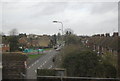
3
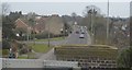
Buckingham Road, Bicester
Looking northwards from near the Bicester North station.
Image: © Robert Eva
Taken: 23 Mar 2017
0.07 miles
5
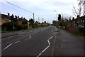
Buckingham Road, Bicester
Looking NNE along Buckingham Road from the railway bridge.
Image: © David P Howard
Taken: 13 Apr 2014
0.08 miles
7
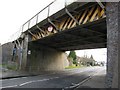
Rail Bridge (Banbury Road)
A close up view of the railway bridge spanning Banbury Road in Bicester. Looking south here, the miniroundabout junction that leads into the Town Centre is just out of view.
Image: © Kurt C
Taken: 1 Mar 2009
0.09 miles
8
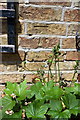
Benchmark on #98 Banbury Road, Bicester
1970 Ordnance Survey cut mark benchmark on the north side of #98 Banbury Road. See http://www.bench-marks.org.uk/bm33944 for details.
Image: © Roger Templeman
Taken: 12 Apr 2010
0.10 miles
9
#98 Banbury Road
There is an Ordnance Survey cut mark benchmark Image on the left hand side of the house about 2ft from the front corner
Image: © Roger Templeman
Taken: 9 Jun 2014
0.10 miles