IMAGES TAKEN NEAR TO
Buchan Road, BICESTER, OX26 2YQ
Introduction
This page details the photographs taken nearby to Buchan Road, OX26 2YQ by members of the Geograph project.
The Geograph project started in 2005 with the aim of publishing, organising and preserving representative images for every square kilometre of Great Britain, Ireland and the Isle of Man.

There are currently over 7.5m images from over14,400 individuals and you can help contribute to the project by visiting https://www.geograph.org.uk
Image Map
Images are licensed for reuse under creativecommons.org/licenses/by-sa/2.0
Notes
- Clicking on the map will re-center to the selected point.
- The higher the marker number, the further away the image location is from the centre of the postcode.
Image Listing (23 Images Found)
Images are licensed for reuse under creativecommons.org/licenses/by-sa/2.0
Image
Details
Distance
1
Bicester, #3 Buchan Road benchmark
1971 Ordnance Survey cut mark benchmark on angle of #3 Buchan Road on the 4/5th brick courses above ground. The mark was levelled at 84.0578m above Newlyn datum. For more details of this and other nearby benchmarks see http://www.bench-marks.org.uk/bm34186.
Image: © Roger Templeman
Taken: 28 Apr 2010
0.04 miles

4
Shakespeare Drive in Bicester
Heading north-east to Howes Lane.
Image: © Steve Daniels
Taken: 1 Jul 2014
0.12 miles
5
#1 Keats Close at Browning Drive junction
Image: © Roger Templeman
Taken: 22 Dec 2017
0.14 miles
6
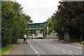
Bucknell Road looking north-west
A railway bridge crosses Bucknell Road in the distance.
Image: © Steve Daniels
Taken: 1 Jul 2014
0.16 miles
7
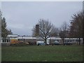
King's Meadow Primary School, Bicester
Image: © Sarah Charlesworth
Taken: 13 Nov 2009
0.16 miles
8
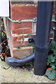
Benchmark on #107 Bucknell Road
Ordnance Survey cut mark benchmark described on the Bench Mark Database at http://www.bench-marks.org.uk/bm33935
Image: © Roger Templeman
Taken: 4 Nov 2013
0.18 miles
9
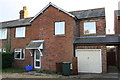
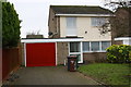
#107 Bucknell Road
There is an OS benchmark Image on the corner of the house left of the garage door (behind a chest of drawers)
Image: © Roger Templeman
Taken: 4 Nov 2013
0.18 miles
10
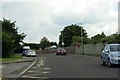
Junction of Shakespeare Drive with Howes Lane
Howes Lane is the A4095 which encircles the NW limit of urbanised Bicester
Image: © Roger Templeman
Taken: 4 Nov 2013
0.19 miles