IMAGES TAKEN NEAR TO
Queens Avenue, BICESTER, OX26 2NT
Introduction
This page details the photographs taken nearby to Queens Avenue, OX26 2NT by members of the Geograph project.
The Geograph project started in 2005 with the aim of publishing, organising and preserving representative images for every square kilometre of Great Britain, Ireland and the Isle of Man.

There are currently over 7.5m images from over14,400 individuals and you can help contribute to the project by visiting https://www.geograph.org.uk
Image Map
Images are licensed for reuse under creativecommons.org/licenses/by-sa/2.0
Notes
- Clicking on the map will re-center to the selected point.
- The higher the marker number, the further away the image location is from the centre of the postcode.
Image Listing (107 Images Found)
Images are licensed for reuse under creativecommons.org/licenses/by-sa/2.0
Image
Details
Distance
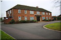
1
Entrance to Bicester Police Station
From Queens Avenue. The station is part of the Thames Valley Police force.
Image: © Jaggery
Taken: 9 Jul 2015
0.01 miles
2

Bicester Telephone Exchange, Oxon
Situated in Queens Avenue, this redbrick TE replaced the former manual TE in the mid 1960s. Besides Bicester, this TE also serves Ambrosden, Blackthorn, Bucknell, Caversfield, Chesterton, Launton and Wendlebury nearby. The postbox can be seen on the far right of the photo, whilst the BT car and yellow grit salt bin are adjacent to the TE itself. The postcode of the TE is OX26 2NR.
Image: © David Hillas
Taken: 9 Apr 2010
0.05 miles
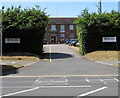
3
Bicester Magistrates' Court
Set back from the west side of Queens Avenue, Bicester.
Image: © Jaggery
Taken: 9 Jul 2015
0.06 miles
4
Bicester Magistrates Court
There is an OS flush bracket benchmark Image on the back of the building
Image: © Roger Templeman
Taken: 22 Dec 2017
0.06 miles
5
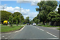
Queens Avenue, Bicester
On a Roman road alignment.
Image: © Robin Webster
Taken: 22 Aug 2020
0.06 miles
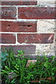
6
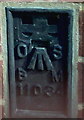
Bicester, Magistrates Court benchmark
Ordnance Survey Flush Bracket benchmark with identification number 11034 mounted on Waverley House, Queens Avenue. See http://www.bench-marks.org.uk/bm19487 for details.
Image: © Roger Templeman
Taken: 9 Apr 2010
0.07 miles
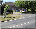
7
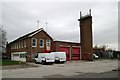
Bicester fire station
Bicester fire station, Queens Avenue, Bicester, Oxfordshire
Image: © Kevin Hale
Taken: 24 Nov 2007
0.10 miles
8
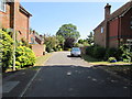
Queens Court, Bicester
Cul-de-sac on the east side of Queens Avenue.
Image: © Jaggery
Taken: 9 Jul 2015
0.10 miles
9
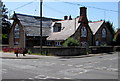
Former Bicester Primary School
Located on the corner at the SE end of Bucknell Road, near Crockwell Close.
Built in 1836 as Bicester Primary School, known locally as Crockwell School.
Converted to four houses in the 1970s. The name plates on the right show
CROCKWELL COTTAGE NO. 2 and OLD SCHOOL COTTAGE.
Image: © Jaggery
Taken: 9 Jul 2015
0.10 miles
10
Benchmark on #4 Crockwell Close
Ordnance Survey cut mark benchmark described on the Bench Mark Database at http://www.bench-marks.org.uk/bm33925
Image: © Roger Templeman
Taken: 4 Nov 2013
0.10 miles