IMAGES TAKEN NEAR TO
Hudson Street, BICESTER, OX26 2ER
Introduction
This page details the photographs taken nearby to Hudson Street, OX26 2ER by members of the Geograph project.
The Geograph project started in 2005 with the aim of publishing, organising and preserving representative images for every square kilometre of Great Britain, Ireland and the Isle of Man.

There are currently over 7.5m images from over14,400 individuals and you can help contribute to the project by visiting https://www.geograph.org.uk
Image Map
Images are licensed for reuse under creativecommons.org/licenses/by-sa/2.0
Notes
- Clicking on the map will re-center to the selected point.
- The higher the marker number, the further away the image location is from the centre of the postcode.
Image Listing (49 Images Found)
Images are licensed for reuse under creativecommons.org/licenses/by-sa/2.0
Image
Details
Distance
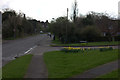
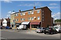
5
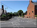
Bucknell Road, Bicester
Viewed across the B4100 Field Street. A nearby sign shows 2 (miles) to Bucknell.
Image: © Jaggery
Taken: 9 Jul 2015
0.12 miles
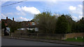
6
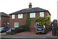
#25 and #27 Bucknell Road
There is an OS benchmark Image on the side of the right hand house, on the corner in front of the metal gate across the side path.
Image: © Roger Templeman
Taken: 4 Nov 2013
0.12 miles
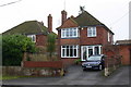
7
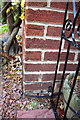
Benchmark on #27 Bucknell Road
Ordnance Survey cut mark benchmark described on the Bench Mark Database at http://www.bench-marks.org.uk/bm33932
Image: © Roger Templeman
Taken: 4 Nov 2013
0.12 miles
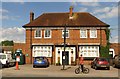
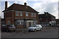
10
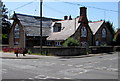
Former Bicester Primary School
Located on the corner at the SE end of Bucknell Road, near Crockwell Close.
Built in 1836 as Bicester Primary School, known locally as Crockwell School.
Converted to four houses in the 1970s. The name plates on the right show
CROCKWELL COTTAGE NO. 2 and OLD SCHOOL COTTAGE.
Image: © Jaggery
Taken: 9 Jul 2015
0.17 miles