IMAGES TAKEN NEAR TO
St. Edburgs Close, BICESTER, OX26 2BL
Introduction
This page details the photographs taken nearby to St. Edburgs Close, OX26 2BL by members of the Geograph project.
The Geograph project started in 2005 with the aim of publishing, organising and preserving representative images for every square kilometre of Great Britain, Ireland and the Isle of Man.

There are currently over 7.5m images from over14,400 individuals and you can help contribute to the project by visiting https://www.geograph.org.uk
Image Map
Images are licensed for reuse under creativecommons.org/licenses/by-sa/2.0
Notes
- Clicking on the map will re-center to the selected point.
- The higher the marker number, the further away the image location is from the centre of the postcode.
Image Listing (12 Images Found)
Images are licensed for reuse under creativecommons.org/licenses/by-sa/2.0
Image
Details
Distance
5
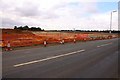
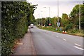
New development on Middleton Cheney Road
Image: © Steve Daniels
Taken: 14 Aug 2010
0.20 miles
7
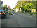
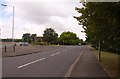
Middleton Stoney Road, Bicester
Towards the town centre.
Image: © Robin Webster
Taken: 22 Aug 2020
0.21 miles
8
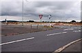
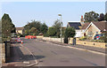
The junction of Shakespeare Drive and Middleton Cheney Road
Image: © Steve Daniels
Taken: 14 Aug 2010
0.22 miles
9
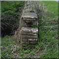
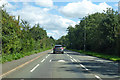
Bicester, Middleton Stoney Road
Bridge on Middleton Stoney road with top stone on east end missing: a stone which carried a 1970 Ordnance Survey benchmark. See http://www.bench-marks.org.uk/bm33929
Image: © Roger Templeman
Taken: 9 Apr 2010
0.23 miles
10
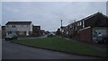
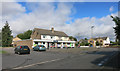
Modern housing on the outskirts of Bicester
Image: © Sarah Charlesworth
Taken: 13 Nov 2009
0.23 miles