IMAGES TAKEN NEAR TO
Ray Road, BICESTER, OX26 2AG
Introduction
This page details the photographs taken nearby to Ray Road, OX26 2AG by members of the Geograph project.
The Geograph project started in 2005 with the aim of publishing, organising and preserving representative images for every square kilometre of Great Britain, Ireland and the Isle of Man.

There are currently over 7.5m images from over14,400 individuals and you can help contribute to the project by visiting https://www.geograph.org.uk
Image Map
Images are licensed for reuse under creativecommons.org/licenses/by-sa/2.0
Notes
- Clicking on the map will re-center to the selected point.
- The higher the marker number, the further away the image location is from the centre of the postcode.
Image Listing (40 Images Found)
Images are licensed for reuse under creativecommons.org/licenses/by-sa/2.0
Image
Details
Distance
1
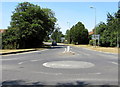
Middleton Stoney Road, Bicester
The B4030 Middleton Stoney Road heads away from the mini-roundabout at the Oxford Road/King's End junction. Middleton Stoney is 3 miles (5km) ahead.
Image: © Jaggery
Taken: 9 Jul 2015
0.04 miles
2
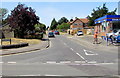
Kings Avenue, Bicester
Viewed across King's End from the corner of Piggy Lane. A Kwik Fit Plus http://www.geograph.org.uk/photo/4563844 is on the right.
Image: © Jaggery
Taken: 9 Jul 2015
0.09 miles
3
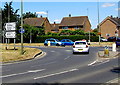
Distances from Bicester
Viewed across Oxford Road. Signs pointing along Middleton Stoney Road
show Witney 19 (miles), Enstone 14, Kirtlington 8, Middleton Stoney 3.
Image: © Jaggery
Taken: 9 Jul 2015
0.10 miles
5
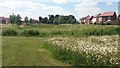
Green Space
Green space between the new developments of Goodwood Close and Redcar Road
Image: © Shaun Ferguson
Taken: 3 Jul 2019
0.11 miles
6
This way to Bicester Town Colts FC
Viewed from the edge of King's End near the Oxford Road junction.
The arrow on the notice on the wall points ahead for Bicester Town Colts FC (football club).
Image: © Jaggery
Taken: 9 Jul 2015
0.12 miles
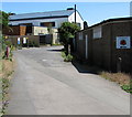
7
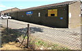
Bicester Rugby Club
Rugby ground building near Oxford Road.
Image: © Jaggery
Taken: 9 Jul 2015
0.12 miles
8

X5 bus to Oxford in Bicester
Stagecoach bus fleet number 54315 is at an Oxford Road bus stop on route X5
from Cambridge to Oxford via Bedford, Milton Keynes, Buckingham and Bicester.
Image: © Jaggery
Taken: 9 Jul 2015
0.13 miles
9

Kwik Fit Plus in Bicester
On the corner of King's End and Kings Avenue. The Kwik Fit website states that a Kwik Fit Plus differs from a standard Kwik Fit in these ways:
There is a separate team of fast fit and slow fit technicians offering a range of products each led by a supervisor and all work overseen by a quality controller and manager.
The slow fit team includes Master Technicians trained to the highest level recognised by the Automotive Technician Accreditation. Trained to handle the most complex electrical and mechanical repair work on company cars and vans they are now centre-based instead of operating on a mobile basis covering a number of outlets.
There is an increased focus on training and development for all employees.
Image: © Jaggery
Taken: 9 Jul 2015
0.13 miles
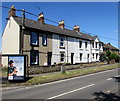
10
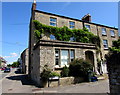
South View, Bicester
House on the corner of Piggy Lane and King's End.
Image: © Jaggery
Taken: 9 Jul 2015
0.13 miles