IMAGES TAKEN NEAR TO
Oxford Road, BICESTER, OX26 1BT
Introduction
This page details the photographs taken nearby to Oxford Road, OX26 1BT by members of the Geograph project.
The Geograph project started in 2005 with the aim of publishing, organising and preserving representative images for every square kilometre of Great Britain, Ireland and the Isle of Man.

There are currently over 7.5m images from over14,400 individuals and you can help contribute to the project by visiting https://www.geograph.org.uk
Image Map
Images are licensed for reuse under creativecommons.org/licenses/by-sa/2.0
Notes
- Clicking on the map will re-center to the selected point.
- The higher the marker number, the further away the image location is from the centre of the postcode.
Image Listing (54 Images Found)
Images are licensed for reuse under creativecommons.org/licenses/by-sa/2.0
Image
Details
Distance
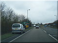
1
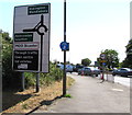
Directions sign near Bicester
Alongside the B4030 on the approach to the A41 roundabout junction
a few tens of metres south of the southern boundary of Bicester.
Image: © Jaggery
Taken: 9 Jul 2015
0.03 miles
2
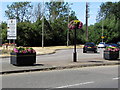
Southern boundary of Bicester
Viewed across the B4030. The boundary sign states that Bicester is (has been?) Britain in Bloom winners.
Examples of Bicester blooms are in view.
Image: © Jaggery
Taken: 9 Jul 2015
0.04 miles
3
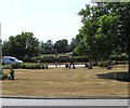
Shepherd and sheep statues on a roundabout near Bicester
In the middle of the roundabout at the A41 Oxford Road/B4030 junction south of Bicester.
Image: © Jaggery
Taken: 9 Jul 2015
0.06 miles
4
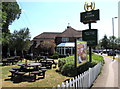
Outdoor eating area, the Acorn, Bicester
On the Oxford Road side of the Acorn, a Hungry Horse pub on the corner of Pingle Drive.
Image: © Jaggery
Taken: 9 Jul 2015
0.07 miles
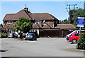
6
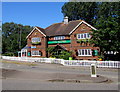
The Acorn, Bicester
A Hungry Horse pub viewed across Pingle Drive.
Image: © Jaggery
Taken: 9 Jul 2015
0.07 miles
8
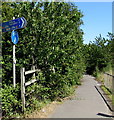
Cycle route distances from the south of Bicester
Alongside the A41. Via National Cycle Network route 51 , it's 5 miles to Kidlington, 10 to Oxford.
Image: © Jaggery
Taken: 9 Jul 2015
0.08 miles
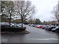
9
The Acorn car park, Bicester
On the east side of the Hungry Horse pub. http://www.geograph.org.uk/photo/4561933 to a view across Pingle Drive.
Image: © Jaggery
Taken: 9 Jul 2015
0.08 miles
10
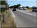
Speed cameras sign alongside the A41, Bicester
The 40mph speed limit past the sign increases to the National Speed Limit out of shot a few tens of metres ahead.
Image: © Jaggery
Taken: 9 Jul 2015
0.09 miles