IMAGES TAKEN NEAR TO
Steeple Barton, BICESTER, OX25 4QS
Introduction
This page details the photographs taken nearby to OX25 4QS by members of the Geograph project.
The Geograph project started in 2005 with the aim of publishing, organising and preserving representative images for every square kilometre of Great Britain, Ireland and the Isle of Man.

There are currently over 7.5m images from over14,400 individuals and you can help contribute to the project by visiting https://www.geograph.org.uk
Image Map
Images are licensed for reuse under creativecommons.org/licenses/by-sa/2.0
Notes
- Clicking on the map will re-center to the selected point.
- The higher the marker number, the further away the image location is from the centre of the postcode.
Image Listing (6 Images Found)
Images are licensed for reuse under creativecommons.org/licenses/by-sa/2.0
Image
Details
Distance
2
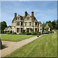
Barton Abbey
Partly 16th century but largely Victorian, and never an abbey.
Image: © Andrew Smith
Taken: 17 Mar 2007
0.07 miles
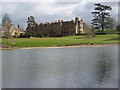
3
Barton Abbey
A view from the footpath to the south.
Image: © Andrew Smith
Taken: 17 Mar 2007
0.07 miles
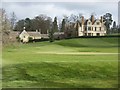
4
Bridleway to Barton Lodge
Bridleway to Barton Lodge passing the thatched pavilion of Barton Abbey cricket field
Image: © Shaun Ferguson
Taken: 30 Apr 2021
0.11 miles
5
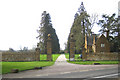
Steeple Barton: Barton Abbey entrance and lodge
Barton Abbey is a private house, not an abbey, and this is one of the entrances to the estate, off the B4030 road.
Image: © Nigel Cox
Taken: 10 Mar 2007
0.22 miles
6
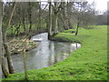
River Dorn in Steeple Barton
Viewed looking downstream from the Pack Lane bridge.
Image: © Nigel Cox
Taken: 10 Mar 2007
0.24 miles