IMAGES TAKEN NEAR TO
West Way, OXFORD, OX2 0PL
Introduction
This page details the photographs taken nearby to West Way, OX2 0PL by members of the Geograph project.
The Geograph project started in 2005 with the aim of publishing, organising and preserving representative images for every square kilometre of Great Britain, Ireland and the Isle of Man.

There are currently over 7.5m images from over14,400 individuals and you can help contribute to the project by visiting https://www.geograph.org.uk
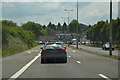
Image Map
Images are licensed for reuse under creativecommons.org/licenses/by-sa/2.0
Notes
- Clicking on the map will re-center to the selected point.
- The higher the marker number, the further away the image location is from the centre of the postcode.
Image Listing (200 Images Found)
Images are licensed for reuse under creativecommons.org/licenses/by-sa/2.0
Image
Details
Distance
2
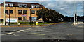
Darbys solicitors Oxford office
In Midland House, West Way. The A420 is on the right.
Image: © Jaggery
Taken: 19 Oct 2014
0.02 miles

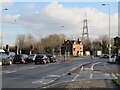
4
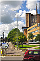
Oxford : West Way
Looking along West Way from the junction at B4044.
Image: © Lewis Clarke
Taken: 29 Jun 2014
0.04 miles
5
Botley : Seacourt Retail Park
Looking across towards buildings on Seacourt Retail Park.
Image: © Lewis Clarke
Taken: 29 Jun 2014
0.04 miles
6
Westway to the lights
Westway, Botley, towards the traffic lights. After that it becomes the Botley Road into Oxford.
Image: © Bill Nicholls
Taken: 17 Dec 2009
0.05 miles
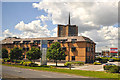
7
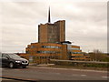
Botley: Seacroft Tower from the A34
This wonderful art-deco former office building is an unmissable landmark on the Oxford By-Pass section of the A34. I took advantage of a nauseating ¾-hour period of almost stationary traffic to take a photo which it would not normally be safe to take! It would appear to be a shopping outlet now, but this is as close as I have ever been to it.
Image: © Chris Downer
Taken: 16 Apr 2010
0.05 miles
8
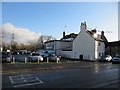
McDonald's carpark
Used to be the Carpenters Arms public house.
Image: © Bill Nicholls
Taken: 17 Dec 2009
0.05 miles
9
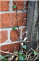
Benchmark partly hidden by fence post on #16 West Way
Ordnance Survey cut mark benchmark levelled at 57.347m above mean sea level
Image: © Roger Templeman
Taken: 14 Mar 2018
0.05 miles
10
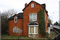
#16 West Way, aka 'Boundary House'
There is an OS benchmark Image on the right hand facing corner behind the ivy.
Image: © Roger Templeman
Taken: 14 Mar 2018
0.05 miles