IMAGES TAKEN NEAR TO
Stanley Close, OXFORD, OX2 0LB
Introduction
This page details the photographs taken nearby to Stanley Close, OX2 0LB by members of the Geograph project.
The Geograph project started in 2005 with the aim of publishing, organising and preserving representative images for every square kilometre of Great Britain, Ireland and the Isle of Man.

There are currently over 7.5m images from over14,400 individuals and you can help contribute to the project by visiting https://www.geograph.org.uk
Image Map
Images are licensed for reuse under creativecommons.org/licenses/by-sa/2.0
Notes
- Clicking on the map will re-center to the selected point.
- The higher the marker number, the further away the image location is from the centre of the postcode.
Image Listing (174 Images Found)
Images are licensed for reuse under creativecommons.org/licenses/by-sa/2.0
Image
Details
Distance
2
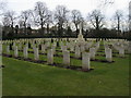
Commonwealth War Graves
Commonwealth War Graves in Botley cemetery
Image: © Shaun Ferguson
Taken: 4 Dec 2009
0.06 miles
3
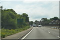
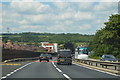
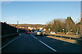
A34 and Southern By-pass at Botley
Restricted by an oft violated 50 MPH speed limit and corralled by high fencing, it's possible that some long distance travellers on the A34 see the Southern By-pass as a hindrance rather than a help.
Image: © Stuart Logan
Taken: 31 Jul 2011
0.06 miles
4

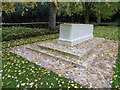
Stone of Remembrance in Botley Cemetery
The stone was designed by Sir Edwin Lutyens for the Commonwealth War Graves Commission.
Image: © Steve Daniels
Taken: 22 Dec 2013
0.06 miles
5
2020 vision Day 301
The vision was a bit blowy here at the Stone of Remembrance in Botley Cemetery
Temperature 12C
BBC Radio Four, 'The World at One', closing headline 13:45- scientists leading a government commissioned study of Coronavirus have said a vaccine could still be effective despite data suggesting a quite rapid fall in antibody levels after infection.
Image: © Basher Eyre
Taken: 27 Oct 2020
0.06 miles
6
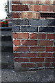
Benchmark on #88 Westminster Way
Ordnance Survey cut mark benchmark described on the Bench Mark Database at http://www.bench-marks.org.uk/bm39269
Image: © Roger Templeman
Taken: 24 Aug 2011
0.06 miles
7
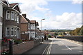
Westminster Way and Southern Bypass Road
On the far side of the first house (#88) is an OS benchmark Image
Image: © Roger Templeman
Taken: 24 Aug 2011
0.06 miles
8
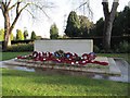
War Memorial at the cemetery
The War Memorial at the War Grave cemetery in Botley.
Image: © Bill Nicholls
Taken: 17 Dec 2009
0.06 miles
10
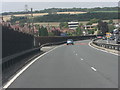
A34 northbound
Passing though Botley.
Image: © Robin Webster
Taken: 28 Dec 2017
0.06 miles