IMAGES TAKEN NEAR TO
Oatlands Road, OXFORD, OX2 0ET
Introduction
This page details the photographs taken nearby to Oatlands Road, OX2 0ET by members of the Geograph project.
The Geograph project started in 2005 with the aim of publishing, organising and preserving representative images for every square kilometre of Great Britain, Ireland and the Isle of Man.

There are currently over 7.5m images from over14,400 individuals and you can help contribute to the project by visiting https://www.geograph.org.uk
Image Map
Images are licensed for reuse under creativecommons.org/licenses/by-sa/2.0
Notes
- Clicking on the map will re-center to the selected point.
- The higher the marker number, the further away the image location is from the centre of the postcode.
Image Listing (265 Images Found)
Images are licensed for reuse under creativecommons.org/licenses/by-sa/2.0
Image
Details
Distance
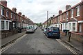
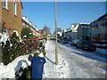
2
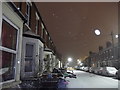
Oatlands Road, Oxford under snow
Late night snow
Image: © Iain Tullis
Taken: 2 Feb 2015
0.02 miles
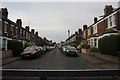
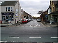
3
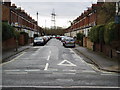
Oatlands Road - Oxford
Junction of Oatlands Road with the Botley Road.
Image: © Malcolm Reid
Taken: 13 Jan 2007
0.03 miles
4
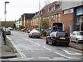
Harley Road - Oxford
Junction of Harley Road with the Botley Road
Image: © Malcolm Reid
Taken: 13 Jan 2007
0.03 miles
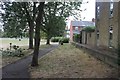
5
Alexandra Road seen from New Botley recreation ground
Image: © Stuart Taylor
Taken: 27 Jul 2018
0.04 miles
7
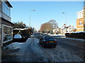
Botley Rd seen from Warland's bicycle shop
Image: © Stuart Taylor
Taken: 25 Dec 2010
0.05 miles
9
Alexandra Road - Oxford
Junction of Alexandra Road with the Botley Road.
Image: © Malcolm Reid
Taken: 13 Jan 2007
0.05 miles
10
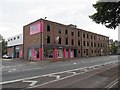
Pink storage
Rather an eye catching pink on this storage facility along the Botley Road, Oxford.
Image: © Bill Nicholls
Taken: 8 Jul 2009
0.05 miles