IMAGES TAKEN NEAR TO
Ferry Hinksey Road, OXFORD, OX2 0DP
Introduction
This page details the photographs taken nearby to Ferry Hinksey Road, OX2 0DP by members of the Geograph project.
The Geograph project started in 2005 with the aim of publishing, organising and preserving representative images for every square kilometre of Great Britain, Ireland and the Isle of Man.

There are currently over 7.5m images from over14,400 individuals and you can help contribute to the project by visiting https://www.geograph.org.uk
Image Map
Images are licensed for reuse under creativecommons.org/licenses/by-sa/2.0
Notes
- Clicking on the map will re-center to the selected point.
- The higher the marker number, the further away the image location is from the centre of the postcode.
Image Listing (178 Images Found)
Images are licensed for reuse under creativecommons.org/licenses/by-sa/2.0
Image
Details
Distance
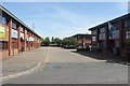
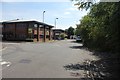
2
Office block on the corner
This block of units and offices was built back in the late 1970s.
Image: © Bill Nicholls
Taken: 30 Dec 2008
0.03 miles
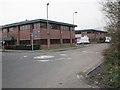
3
Ferry Hinksey Road
Spine road for the Osney Mead insutrial estate.
Image: © Peter Whatley
Taken: 22 Apr 2022
0.04 miles


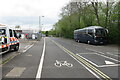
8
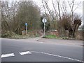
Footpath to Hinksey
This footpath leads to North Hinksey and over the years has been improved to a cycleway.
Image: © Bill Nicholls
Taken: 30 Dec 2008
0.05 miles
9

Countr Griddle
A food bar having trouble with its sign in the yard outside Booker's cash and carry.
Image: © Des Blenkinsopp
Taken: 19 Feb 2013
0.05 miles
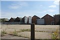
10
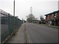
Osney Mead
Road through Osney Mead Industrial Estate.
Image: © Bill Nicholls
Taken: 30 Dec 2008
0.05 miles