IMAGES TAKEN NEAR TO
Ferry Hinksey Road, OXFORD, OX2 0BY
Introduction
This page details the photographs taken nearby to Ferry Hinksey Road, OX2 0BY by members of the Geograph project.
The Geograph project started in 2005 with the aim of publishing, organising and preserving representative images for every square kilometre of Great Britain, Ireland and the Isle of Man.

There are currently over 7.5m images from over14,400 individuals and you can help contribute to the project by visiting https://www.geograph.org.uk
Image Map
Images are licensed for reuse under creativecommons.org/licenses/by-sa/2.0
Notes
- Clicking on the map will re-center to the selected point.
- The higher the marker number, the further away the image location is from the centre of the postcode.
Image Listing (483 Images Found)
Images are licensed for reuse under creativecommons.org/licenses/by-sa/2.0
Image
Details
Distance
1
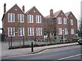
West Oxford Community Primary School (formerly West Oxford First School)
Not changed a lot since I used to drive past to work.
Image: © Bill Nicholls
Taken: 30 Dec 2008
0.01 miles
5
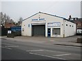
Howkins Garage
Family run garage that also rents out vans. When Oxford Instruments moved from Osney to Eynsham back in the 1980's we hired out every van they had for the weekend. Good to see they are still going.
Image: © Bill Nicholls
Taken: 30 Dec 2008
0.03 miles
6

West Oxford Community Primary School (formerly West Oxford First School)
Image: © Stuart Taylor
Taken: 4 Aug 2018
0.03 miles
7
New charging point, Osney Island
Milk bottles delivered to the new electric car charging point.
Image: © Iain Tullis
Taken: 22 Apr 2018
0.04 miles

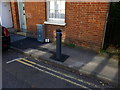
9
Broken charging point
The electric car charging point was located in the wrong position, right where the passing spot is, and has been hit and damaged. The council has wrapped it in warning tape.
Image: © Iain Tullis
Taken: 23 Sep 2018
0.04 miles
10

Footbridge from Swan Street
The footbridge connects Osney Island and Osney Mead.
Image: © Steve Daniels
Taken: 22 Sep 2012
0.05 miles