IMAGES TAKEN NEAR TO
Rosamund Drive, WOODSTOCK, OX20 1YE
Introduction
This page details the photographs taken nearby to Rosamund Drive, OX20 1YE by members of the Geograph project.
The Geograph project started in 2005 with the aim of publishing, organising and preserving representative images for every square kilometre of Great Britain, Ireland and the Isle of Man.

There are currently over 7.5m images from over14,400 individuals and you can help contribute to the project by visiting https://www.geograph.org.uk
Image Map
Images are licensed for reuse under creativecommons.org/licenses/by-sa/2.0
Notes
- Clicking on the map will re-center to the selected point.
- The higher the marker number, the further away the image location is from the centre of the postcode.
Image Listing (33 Images Found)
Images are licensed for reuse under creativecommons.org/licenses/by-sa/2.0
Image
Details
Distance
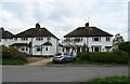
1
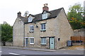
#129 Manor Road, 'Carolines Cottage' beside A44
There is an OS benchmark Image on a stone in the house wall at the left side of the blue door
Image: © Roger Templeman
Taken: 20 Oct 2014
0.07 miles
2
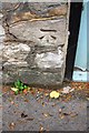
Benchmark on #129 Manor Road
Ordnance Survey cut mark benchmark described on the Bench Mark Database at http://www.bench-marks.org.uk/bm61337
Image: © Roger Templeman
Taken: 20 Oct 2014
0.07 miles
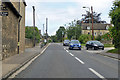
3
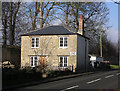
Old Toll House by the A44, Old Woodstock
Toll House in the parish of Woodstock, The Old Gate House, No.131 Manor Road (A44), OX20 1XS.
Oxfordshire HER.
HER Number: 4386 https://www.heritagegateway.org.uk/Gateway/Results_Single.aspx?uid=MOX1468&resourceID=1033
Surveyed
Milestone Society National ID: OX.WOO
Image: © Alan Rosevear
Taken: 16 Jan 2005
0.07 miles
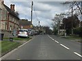
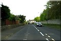
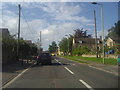
8
A44 Manor Road
Heading north through Old Woodstock.
Image: © Robin Webster
Taken: 11 Aug 2019
0.14 miles
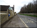
10
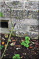
Benchmark on #83 Manor Road
Ordnance Survey cut mark benchmark described on the Bench Mark Database at http://www.bench-marks.org.uk/bm61446
Image: © Roger Templeman
Taken: 20 Oct 2014
0.16 miles