IMAGES TAKEN NEAR TO
Park Lane, WOODSTOCK, OX20 1UD
Introduction
This page details the photographs taken nearby to Park Lane, OX20 1UD by members of the Geograph project.
The Geograph project started in 2005 with the aim of publishing, organising and preserving representative images for every square kilometre of Great Britain, Ireland and the Isle of Man.

There are currently over 7.5m images from over14,400 individuals and you can help contribute to the project by visiting https://www.geograph.org.uk
Image Map (Loading...)


Getting Data...Please wait
Leaflet Map data © OpenStreetMap
Images are licensed for reuse under creativecommons.org/licenses/by-sa/2.0
Notes
- Clicking on the map will re-center to the selected point.
- The higher the marker number, the further away the image location is from the centre of the postcode.
Image Listing (353 Images Found)
Images are licensed for reuse under creativecommons.org/licenses/by-sa/2.0
Image
Details
Distance
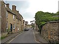
1
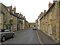
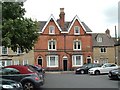
Park Lane
A quiet street of attractive houses plus a pub, in this delightful Oxfordshire town.
Image
Image: © P L Chadwick
Taken: 3 May 2010
0.00 miles
2
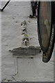
Faces in the wall
Wonderful plaster faces set into the wall of The King's Head pub in Woodstock.
Image: © Colin Craig
Taken: 27 Nov 2007
0.01 miles
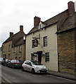
3
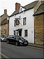
The King's Head, 11 Park Lane
Not to be confused with the King's Arms, also in Woodstock. The King's Head is a pub and dining room hidden away in a backwater of the town. The pub has been going since 1801, but the building is earlier. The date above the door is 1735. The pub has a courtyard garden with seats and tables.
Image
Image
Image: © P L Chadwick
Taken: 3 May 2010
0.01 miles
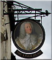
4
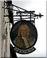
The King's Head sign, 11 Park Lane
The sign would appear to be a portrait of King George III, who was on the throne in 1801, when the pub was opened.
Image
Image: © P L Chadwick
Taken: 3 May 2010
0.01 miles
5
Victorian Houses, Woodstock Market Place
A pair of interesting Victorian red brick houses among the Cotswold stone buildings of Woodstock... built before the town planners came on the scene and insisted on local stone only!
Image: © Paul Shreeve
Taken: 11 Jul 2009
0.01 miles
6
The Kings Head name sign, Woodstock
Hanging from a Park Lane wall bracket here. http://www.geograph.org.uk/photo/4533727
Image: © Jaggery
Taken: 20 Jun 2015
0.01 miles
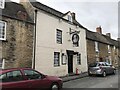
7
The Kings Head, Woodstock
Pub in Park Lane, a quiet street on the south side of the much busier High Street.
Image: © Jaggery
Taken: 20 Jun 2015
0.01 miles
8
The King's Head, Woodstock
18th century, Grade II listed, see https://historicengland.org.uk/listing/the-list/list-entry/1262219
Image: © Jonathan Hutchins
Taken: 14 Sep 2018
0.01 miles
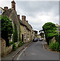
9
Park Lane
Park Lane, not to be confused with Park Street, is a quiet backwater of Woodstock, which contains one pub, the King's Head. In the far distance the lane joins Rectory Lane.
Image: © P L Chadwick
Taken: 3 May 2010
0.02 miles
10
West along Park Lane, Woodstock
Looking towards Rectory Lane.
Image: © Jaggery
Taken: 20 Jun 2015
0.03 miles