IMAGES TAKEN NEAR TO
WOODSTOCK, OX20 1HD
Introduction
This page details the photographs taken nearby to OX20 1HD by members of the Geograph project.
The Geograph project started in 2005 with the aim of publishing, organising and preserving representative images for every square kilometre of Great Britain, Ireland and the Isle of Man.

There are currently over 7.5m images from over14,400 individuals and you can help contribute to the project by visiting https://www.geograph.org.uk
Image Map (Loading...)


Getting Data...Please wait
Leaflet Map data © OpenStreetMap
Images are licensed for reuse under creativecommons.org/licenses/by-sa/2.0
Notes
- Clicking on the map will re-center to the selected point.
- The higher the marker number, the further away the image location is from the centre of the postcode.
Image Listing (17 Images Found)
Images are licensed for reuse under creativecommons.org/licenses/by-sa/2.0
Image
Details
Distance
1
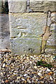
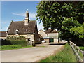
Benchmark on cottage at Park Farm
Ordnance Survey cut mark benchmark described on the Bench Mark Database at http://www.bench-marks.org.uk/bm73763
Image: © Roger Templeman
Taken: 27 Feb 2016
0.01 miles
2
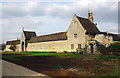
Buildings at Park Farm
There is an OS benchmark Image on the near corner, right hand face, of the porch of the cottage at the right hand side of the image
Image: © Roger Templeman
Taken: 27 Feb 2016
0.01 miles
3
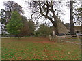
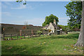
Park Farm, Blenheim Park
From footpath now designated Shakespeare's Way.
Image: © Liz Stone
Taken: 8 Oct 2011
0.02 miles
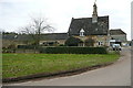
4
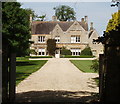
Park Farm, Blenheim
The farm was built by Capability Brown in 1768 but remodelled in 1858, according to Pevsner. View from public footpath which comes along the park road to this gate, then turns north.
Image: © David Hawgood
Taken: 22 May 2007
0.02 miles
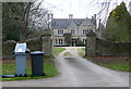
5
Driveway to Park Farm
Looking more like a minor country house than a working farm, Park Farm House and its buildings are designed with the style that befits the grand estate of which they are a part..
Image: © Des Blenkinsopp
Taken: 22 Apr 2019
0.02 miles
6
Park Farm
This is the entrance to the farmhouse of Park Farm, the estate's own farm. A public footpath, used by Shakespeare's Way, comes along from where I am standing and turns right.
Image: © Graham Horn
Taken: 24 Feb 2013
0.03 miles
7
Park Farm
The main farm within the Blenheim estate. A public footpath, used by Shakespeare's Way, passes here.
Image: © Graham Horn
Taken: 24 Feb 2013
0.03 miles
8
Park Farm
The centre of operations for the surrounding sheep farming.
Image: © Bill Boaden
Taken: 20 Aug 2015
0.03 miles
9
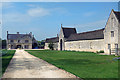
Part of Park Farm
The buildings at Park Farm are quite extensive and include a mixture of old and new barns plus several residences.
Image: © Des Blenkinsopp
Taken: 22 Apr 2019
0.03 miles
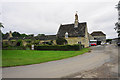
10
Buildings of Park Farm, Blenheim Park
A very neat and tidy farmyard, as one would expect in the grounds of a palace. See Image for photo of the farmhouse, and some history.
Image: © David Hawgood
Taken: 22 May 2007
0.06 miles