IMAGES TAKEN NEAR TO
Taylors Close, WOODSTOCK, OX20 1FZ
Introduction
This page details the photographs taken nearby to Taylors Close, OX20 1FZ by members of the Geograph project.
The Geograph project started in 2005 with the aim of publishing, organising and preserving representative images for every square kilometre of Great Britain, Ireland and the Isle of Man.

There are currently over 7.5m images from over14,400 individuals and you can help contribute to the project by visiting https://www.geograph.org.uk
Image Map
Images are licensed for reuse under creativecommons.org/licenses/by-sa/2.0
Notes
- Clicking on the map will re-center to the selected point.
- The higher the marker number, the further away the image location is from the centre of the postcode.
Image Listing (34 Images Found)
Images are licensed for reuse under creativecommons.org/licenses/by-sa/2.0
Image
Details
Distance
1
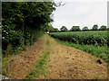
Track north from Oxford Road, Woodstock
Towards Crecy Walk and Princes Ride.
Image: © Jaggery
Taken: 20 Jun 2015
0.02 miles
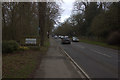
3
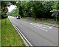
From 30 to 50 along Oxford Road, Woodstock
The 30mph speed limit increases to 50mph at the SE edge of Woodstock.
Image: © Jaggery
Taken: 20 Jun 2015
0.05 miles
4
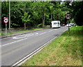
Start of the 30 zone in Woodstock
The 50mph speed limit alongside the A44 Oxford Road drops to 30mph at the SE edge of Woodstock.
Image: © Jaggery
Taken: 20 Jun 2015
0.05 miles
5
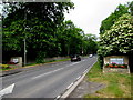
Woodstock boundary signs
The A44 Oxford Road passes the SE boundary of Woodstock.
Image: © Jaggery
Taken: 20 Jun 2015
0.05 miles
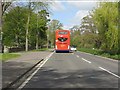
6
Entering Woodstock
Heading north on Shakespeare's Way one would meet the Oxford Road here, thus rejoining what was probably his original route. We are heading away from Woodstock though, thus leaving this road.
Image: © Graham Horn
Taken: 16 Mar 2013
0.05 miles
8
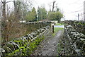
Footpath to Oxford Road
This footpath has come from Bladon, along the east side of the Blenheim Park estate, and comes out onto Oxford Road A44 just by the Woodstock entrance sign. This is a section of Shakespeare's Way.
Image: © Graham Horn
Taken: 16 Mar 2013
0.06 miles
9
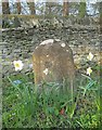
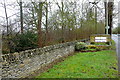
Old Milestone by the A44, Oxford Road, Woodstock
Toll House by the A44, in parish of Woodstock (West Oxfordshire District), Oxford Road; Blenheim Lower Park, opposite Long Close, on grass verge between path and dry stone wall.
Inscription once read:-
(LONDON)
(62)
(OXFORD)
(7)
Oxfordshire HER.
HER Number: 10047 https://www.heritagegateway.org.uk/Gateway/Results_Single.aspx?uid=MOX3853&resourceID=1033
Surveyed
Milestone Society National ID: OX_lw62
Image: © Milestone Society
Taken: Unknown
0.06 miles
10
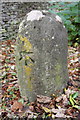
Benchmarked milestone (Oxford 7, London 62) beside A44
Ordnance Survey cut mark benchmark described on the Bench Mark Database at http://www.bench-marks.org.uk/bm20449
Image: © Roger Templeman
Taken: 20 Oct 2014
0.06 miles