IMAGES TAKEN NEAR TO
Wootton, WOODSTOCK, OX20 1AG
Introduction
This page details the photographs taken nearby to OX20 1AG by members of the Geograph project.
The Geograph project started in 2005 with the aim of publishing, organising and preserving representative images for every square kilometre of Great Britain, Ireland and the Isle of Man.

There are currently over 7.5m images from over14,400 individuals and you can help contribute to the project by visiting https://www.geograph.org.uk
Image Map
Images are licensed for reuse under creativecommons.org/licenses/by-sa/2.0
Notes
- Clicking on the map will re-center to the selected point.
- The higher the marker number, the further away the image location is from the centre of the postcode.
Image Listing (3 Images Found)
Images are licensed for reuse under creativecommons.org/licenses/by-sa/2.0
Image
Details
Distance
1
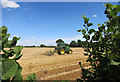
Tractor working at Upper Dornford Farm
Image: © Des Blenkinsopp
Taken: 29 Jul 2014
0.09 miles
2
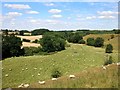
Sheep in the Dorn Valley
The River Dorn joins the Glyme at Wootton, then the Evenlode and eventually the Thames.
Image: © Des Blenkinsopp
Taken: 29 Jul 2014
0.13 miles
3
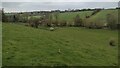
Path goes over the River Dorn Footbridge
From Upper Dornford Farm the path goes over the River Dorn footbridge heading towards Woottondown Farm
Image: © Shaun Ferguson
Taken: 21 Apr 2021
0.16 miles