IMAGES TAKEN NEAR TO
Sycamore Place, BURFORD, OX18 4XG
Introduction
This page details the photographs taken nearby to Sycamore Place, OX18 4XG by members of the Geograph project.
The Geograph project started in 2005 with the aim of publishing, organising and preserving representative images for every square kilometre of Great Britain, Ireland and the Isle of Man.

There are currently over 7.5m images from over14,400 individuals and you can help contribute to the project by visiting https://www.geograph.org.uk
Image Map (Loading...)


Getting Data...Please wait
Leaflet Map data © OpenStreetMap
Images are licensed for reuse under creativecommons.org/licenses/by-sa/2.0
Notes
- Clicking on the map will re-center to the selected point.
- The higher the marker number, the further away the image location is from the centre of the postcode.
Image Listing (8 Images Found)
Images are licensed for reuse under creativecommons.org/licenses/by-sa/2.0
Image
Details
Distance
2
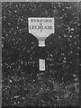
Old Milepost by the A361, south of Signet, Shilton parish
Milepost by the A361, in parish of Shilton (West Oxfordshire District), South of Signet, opposite Upper Glissard's Plantation, by the East side of the road.
Lost since 1940, so this might be the only photograph in existence.
Inscription reads:-
BURFORD
2
LECHLADE
7
Milestone Society National ID: OX_BFLC02
Image: © Milestone Society
Taken: Unknown
0.07 miles
3
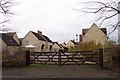
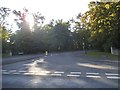
New housing in the country
On the site of the old Burford Hospital, which was closed in 2000.
Image: © Jonathan Billinger
Taken: 14 Dec 2006
0.10 miles
6

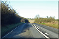
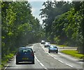
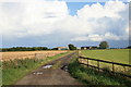
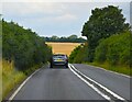
A361 towards Burford
By the turning for Bradwell Village.
Image: © Robin Webster
Taken: 19 Jan 2020
0.17 miles