IMAGES TAKEN NEAR TO
Witney Street, BURFORD, OX18 4SN
Introduction
This page details the photographs taken nearby to Witney Street, OX18 4SN by members of the Geograph project.
The Geograph project started in 2005 with the aim of publishing, organising and preserving representative images for every square kilometre of Great Britain, Ireland and the Isle of Man.

There are currently over 7.5m images from over14,400 individuals and you can help contribute to the project by visiting https://www.geograph.org.uk
Image Map (Loading...)


Getting Data...Please wait
Leaflet Map data © OpenStreetMap
Images are licensed for reuse under creativecommons.org/licenses/by-sa/2.0
Notes
- Clicking on the map will re-center to the selected point.
- The higher the marker number, the further away the image location is from the centre of the postcode.
Image Listing (865 Images Found)
Images are licensed for reuse under creativecommons.org/licenses/by-sa/2.0
Image
Details
Distance
1
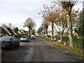
The tree-lined approach to Burford from the east
This attractive approach along the Windrush valley is now used mainly by locals. Visitors will nearly always use the A40 to the south (left) and enter down the steep hill which is Burford's High Street.
Image: © David Purchase
Taken: 23 Nov 2011
0.01 miles
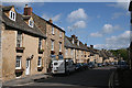
2
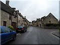
Witney Street, Burford
The name derives from "Burgh" (hilltop) and "ford" (river crossing). Burford was witness to an important episode in the English Civil War in May 1649 when mutineers from Cromwell's New Model Army were imprisoned in the parish church.
Image: © Bikeboy
Taken: 7 Apr 2014
0.01 miles
3
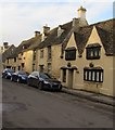
Grade II Listed Gable Cottage, Witney Street, Burford
The cottage dating from c1600 has a twin gabled front
in the traditional Cotswold manner. Grade II Listed in 1955.
Image: © Jaggery
Taken: 16 Jan 2018
0.01 miles
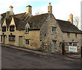
4
Grade II Listed Porters Cottage, Burford
The house with the green door is Porters Cottage at 53 Witney Street.
Image: © Jaggery
Taken: 16 Jan 2018
0.01 miles
5
Burford: Witney Street
By Guildenford and the Royal Oak inn
Image: © Martin Bodman
Taken: 8 May 2009
0.01 miles
6
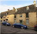
Grade II Listed Hollyhock Cottage, Witney Street, Burford
Gable Cottage https://www.geograph.org.uk/photo/6421209 on the left is also Grade II Listed.
Image: © Jaggery
Taken: 16 Jan 2018
0.01 miles
7
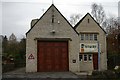
Burford fire station
Burford fire station, Witney Street, Burford, Oxfordshire
Image: © Kevin Hale
Taken: 24 Nov 2007
0.02 miles
8
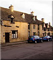
Grade II Listed Leather Alley Cottage, Burford
On the left at 47 Witney Street.
Image: © Jaggery
Taken: 16 Jan 2018
0.02 miles
9
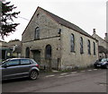
Burford Baptist Church, Burford
The Grade II listed church at 34 Witney Street dates from 1804, built on the site of an earlier church or chapel.
Image: © Jaggery
Taken: 16 Jan 2018
0.02 miles
10
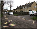
Keep Clear Zone, Witney Street, Burford
Outside Burford Fire Station. https://www.geograph.org.uk/photo/5654452
Image: © Jaggery
Taken: 16 Jan 2018
0.02 miles