IMAGES TAKEN NEAR TO
Wysdom Way, BURFORD, OX18 4NG
Introduction
This page details the photographs taken nearby to Wysdom Way, OX18 4NG by members of the Geograph project.
The Geograph project started in 2005 with the aim of publishing, organising and preserving representative images for every square kilometre of Great Britain, Ireland and the Isle of Man.

There are currently over 7.5m images from over14,400 individuals and you can help contribute to the project by visiting https://www.geograph.org.uk
Image Map (Loading...)


Getting Data...Please wait
Leaflet Map data © OpenStreetMap
Images are licensed for reuse under creativecommons.org/licenses/by-sa/2.0
Notes
- Clicking on the map will re-center to the selected point.
- The higher the marker number, the further away the image location is from the centre of the postcode.
Image Listing (36 Images Found)
Images are licensed for reuse under creativecommons.org/licenses/by-sa/2.0
Image
Details
Distance
1
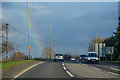
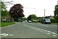
Burford : The A40
The A40 heading out from Burford.
Image: © Lewis Clarke
Taken: 18 Mar 2019
0.12 miles
2
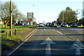
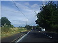
A40 towards Oxford, Burford
By the B4020 turning towards Faringdon, Carterton and RAF Brize Norton.
Image: © Robin Webster
Taken: 19 Jan 2020
0.13 miles
9
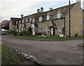
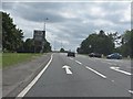
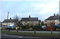
Row of houses, Witney Street, Burford
East of the Windrush Close junction on the right.
Image: © Jaggery
Taken: 16 Jan 2018
0.17 miles
10
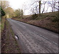
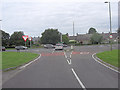
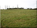
Unclassified road from Burford towards Witney, Oxfordshire
Witney Street beyond the eastern edge of Burford. Witney Image is about 10km ahead.
Image: © Jaggery
Taken: 16 Jan 2018
0.18 miles