IMAGES TAKEN NEAR TO
South Lawn, OX18 4FH
Introduction
This page details the photographs taken nearby to South Lawn, OX18 4FH by members of the Geograph project.
The Geograph project started in 2005 with the aim of publishing, organising and preserving representative images for every square kilometre of Great Britain, Ireland and the Isle of Man.

There are currently over 7.5m images from over14,400 individuals and you can help contribute to the project by visiting https://www.geograph.org.uk
Image Map (Loading...)


Getting Data...Please wait
Leaflet Map data © OpenStreetMap
Images are licensed for reuse under creativecommons.org/licenses/by-sa/2.0
Notes
- Clicking on the map will re-center to the selected point.
- The higher the marker number, the further away the image location is from the centre of the postcode.
Image Listing (7 Images Found)
Images are licensed for reuse under creativecommons.org/licenses/by-sa/2.0
Image
Details
Distance
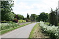
2
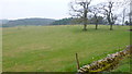
South Lawn
Road heads south from here towards Swinbrook.
Image: © Jonathan Billinger
Taken: 16 Mar 2015
0.16 miles
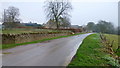
5
Park-like farm land at South Lawn, 2
Oxfrordshire Cotswolds scenery.
Image: © Jonathan Billinger
Taken: 16 Mar 2015
0.22 miles
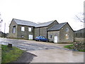
6
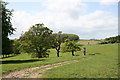
Track across the fields
At South Lawn.
Image: © andrew auger
Taken: 16 May 2009
0.24 miles
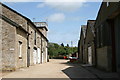
7
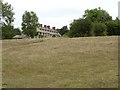
Swinbrook House
Swinbrook House, viewed from the south from the passing road. This house is of interest as it was built in 1926 by the second Baron Redesdale, David Freeman- Mitford, father of the Mitford sisters. They lived here until 1935. In researching this house I discovered it was damaged in a fire in April 2012.
Image: © Philip Halling
Taken: 11 Aug 2018
0.24 miles