IMAGES TAKEN NEAR TO
Meadow Lane, BURFORD, OX18 4BS
Introduction
This page details the photographs taken nearby to Meadow Lane, OX18 4BS by members of the Geograph project.
The Geograph project started in 2005 with the aim of publishing, organising and preserving representative images for every square kilometre of Great Britain, Ireland and the Isle of Man.

There are currently over 7.5m images from over14,400 individuals and you can help contribute to the project by visiting https://www.geograph.org.uk
Image Map
Images are licensed for reuse under creativecommons.org/licenses/by-sa/2.0
Notes
- Clicking on the map will re-center to the selected point.
- The higher the marker number, the further away the image location is from the centre of the postcode.
Image Listing (96 Images Found)
Images are licensed for reuse under creativecommons.org/licenses/by-sa/2.0
Image
Details
Distance
1
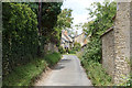
Meadow Lane in Fulbrook
An old narrow street in the village.
Image: © Bill Boaden
Taken: 3 Aug 2020
0.02 miles
3
Fulbrook village centre
Looking towards Burford, with the road to Swinbrook on the left.
Image: © David Hawgood
Taken: 1 Mar 2006
0.07 miles
4
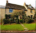
Star Cottage B&B, Meadow Lane, Fulbrook
The Grade II listed cottage dating from the 18th century provides bed & breakfast accommodation.
Image: © Jaggery
Taken: 16 Jan 2018
0.07 miles
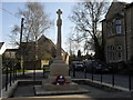
5
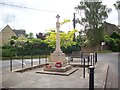
Fulbrook Memorial
War Memorial at Meadow Ln, Fulbrook.
Image: © ROGELIO MONFERRAN
Taken: 16 Jun 2014
0.07 miles
6

Meadow Lane houses behind Fulbrook War Memorial, West Oxfordshire
The house on the right is on the corner of the A361.
The Grade II listed War Memorial was erected in 1922.
Image: © Jaggery
Taken: 16 Jan 2018
0.08 miles
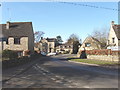
7
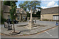
War memorial in Fulbrook
In a small square in the centre of Fulbrook.
Image: © Bill Boaden
Taken: 3 Aug 2020
0.08 miles
8

Entrance to Windrush Farm, Fulbrook
From the south side of the A361. https://www.geograph.org.uk/photo/5659368 to a closer view of the sign on the left.
Image: © Jaggery
Taken: 16 Jan 2018
0.08 miles
9
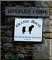
Windrush Belted Galloway depiction, Windrush Farm, Fulbrook
On the wall here. https://www.geograph.org.uk/photo/5659356
Image: © Jaggery
Taken: 16 Jan 2018
0.08 miles
10

Fulbrook Church (Norman) and Fulbrook Meeting Place direction signs
The signs on the south side of the A361 point towards Church Lane. https://www.geograph.org.uk/photo/5659230
Image: © Jaggery
Taken: 16 Jan 2018
0.08 miles