IMAGES TAKEN NEAR TO
Meadow End, BURFORD, OX18 4BQ
Introduction
This page details the photographs taken nearby to Meadow End, OX18 4BQ by members of the Geograph project.
The Geograph project started in 2005 with the aim of publishing, organising and preserving representative images for every square kilometre of Great Britain, Ireland and the Isle of Man.

There are currently over 7.5m images from over14,400 individuals and you can help contribute to the project by visiting https://www.geograph.org.uk
Image Map (Loading...)


Getting Data...Please wait
Leaflet Map data © OpenStreetMap
Images are licensed for reuse under creativecommons.org/licenses/by-sa/2.0
Notes
- Clicking on the map will re-center to the selected point.
- The higher the marker number, the further away the image location is from the centre of the postcode.
Image Listing (548 Images Found)
Images are licensed for reuse under creativecommons.org/licenses/by-sa/2.0
Image
Details
Distance
1
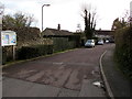
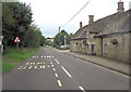
Walnut Row, Fulbrook, West Oxfordshire
From the A361, Walnut Row leads to Meadow End. A Fulbrook Parish Council noticeboard is on the left.
Image: © Jaggery
Taken: 16 Jan 2018
0.03 miles
2
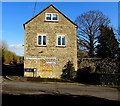
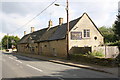
Cotland House B&B, Fulbrook, West Oxfordshire
The Walnut Row side of Cotland House bed & breakfast alongside the A361 Fulbrook Hill.
Image: © Jaggery
Taken: 16 Jan 2018
0.07 miles
3
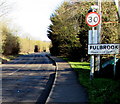
Fulbrook boundary sign
The 40mph speed limit on the A361 from Burford drops to 30mph at the edge of Fulbrook, a village in West Oxfordshire.
Image: © Jaggery
Taken: 16 Jan 2018
0.08 miles
4
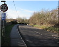
End of the 30mph speed limit beyond Fulbrook, West Oxfordshire
The 30mph speed limit on the A361 increases to 40mph. Ahead for Burford.
Image: © Jaggery
Taken: 16 Jan 2018
0.08 miles
5
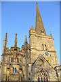
Spire and Facades, Burford
St John the Baptist, Burford does not appear in the Domesday Book but the tower is Norman. The church has an eclectic range of architectural styles as chapels, porches, etc have been added over the centuries. The woollen industry in the Middle Ages was very lucrative, hence the addition of the three-turreted chapel above which also has statues in its niches. The Cotswold limestone used here is probably from the local quarry at Taynton.
Image: © Colin Smith
Taken: 28 Dec 2006
0.09 miles
6

River Windrush
Behind the cemetery at the Burford Church of St John at Easter time 2010.
Image: © R-L-Bowles Meentzen
Taken: 7 Apr 2010
0.09 miles
8
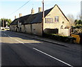
Carpenters Arms, Fulbrook
Viewed across the A361 here named Fulbrook Hill. The name sign shows TRADITIONAL PUB & DINING.
https://www.geograph.org.uk/photo/5655095 to the name sign on a post in the background.
Image: © Jaggery
Taken: 16 Jan 2018
0.10 miles
10
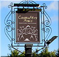
Carpenters Arms name sign, Fulbrook
On a post in the background here. https://www.geograph.org.uk/photo/5655091
Image: © Jaggery
Taken: 16 Jan 2018
0.11 miles