IMAGES TAKEN NEAR TO
OX18 4BP
Introduction
This page details the photographs taken nearby to OX18 4BP by members of the Geograph project.
The Geograph project started in 2005 with the aim of publishing, organising and preserving representative images for every square kilometre of Great Britain, Ireland and the Isle of Man.

There are currently over 7.5m images from over14,400 individuals and you can help contribute to the project by visiting https://www.geograph.org.uk
Image Map (Loading...)


Getting Data...Please wait
Leaflet Map data © OpenStreetMap
Images are licensed for reuse under creativecommons.org/licenses/by-sa/2.0
Notes
- Clicking on the map will re-center to the selected point.
- The higher the marker number, the further away the image location is from the centre of the postcode.
Image Listing (5 Images Found)
Images are licensed for reuse under creativecommons.org/licenses/by-sa/2.0
Image
Details
Distance
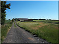
2
Bridleway
Rangehill Copse forms the boundary at the end of the field.
Image: © David Luther Thomas
Taken: 31 Mar 2007
0.07 miles
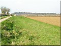
3
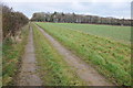
Farm track and bridleway
Farm track and bridleway passing Rangehill Copse on the eastern boundary of the former WWII RAF Windrush airfield.
Image: © Philip Halling
Taken: 14 Dec 2013
0.08 miles
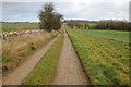
4
Public bridleway towards Rangehill Copse
Image: © Vieve Forward
Taken: 25 Jun 2020
0.20 miles
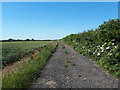
5
Farm road approaching the A40 at Windrush
Farm road and bridleway approaching the A40 at Windrush.
Image: © Philip Halling
Taken: 14 Dec 2013
0.24 miles