IMAGES TAKEN NEAR TO
Burford Road, BURFORD, OX18 4BL
Introduction
This page details the photographs taken nearby to Burford Road, OX18 4BL by members of the Geograph project.
The Geograph project started in 2005 with the aim of publishing, organising and preserving representative images for every square kilometre of Great Britain, Ireland and the Isle of Man.

There are currently over 7.5m images from over14,400 individuals and you can help contribute to the project by visiting https://www.geograph.org.uk
Image Map
Images are licensed for reuse under creativecommons.org/licenses/by-sa/2.0
Notes
- Clicking on the map will re-center to the selected point.
- The higher the marker number, the further away the image location is from the centre of the postcode.
Image Listing (100 Images Found)
Images are licensed for reuse under creativecommons.org/licenses/by-sa/2.0
Image
Details
Distance
1
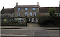
Windrush Farmhouse, Fulbrook
Grade II listed building on the south side of the A361 in Fulbrook, West Oxfordshire.
Image: © Jaggery
Taken: 16 Jan 2018
0.01 miles
2
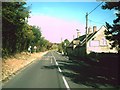
The A361 through Fulbrook
The building is The Carpenters Arms pub.
Image: © andrew auger
Taken: 1 Oct 2009
0.01 miles
3
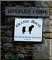
Windrush Belted Galloway depiction, Windrush Farm, Fulbrook
On the wall here. https://www.geograph.org.uk/photo/5659356
Image: © Jaggery
Taken: 16 Jan 2018
0.02 miles
4

Entrance to Windrush Farm, Fulbrook
From the south side of the A361. https://www.geograph.org.uk/photo/5659368 to a closer view of the sign on the left.
Image: © Jaggery
Taken: 16 Jan 2018
0.02 miles
5
Two telecoms cabinets alongside the A361 in Fulbrook, West Oxfordshire
Numbered 4, the Virgin Media cabinet on the left is near a BT cabinet.
Image: © Jaggery
Taken: 16 Jan 2018
0.03 miles
6
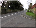
West along the A361, Fulbrook
Viewed from the corner of Church Lane. Ahead for Burford.
Double white lines in the middle of the A361 indicate no overtaking.
Image: © Jaggery
Taken: 16 Jan 2018
0.04 miles
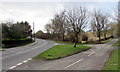
7
Westhall Hill direction sign, Fulbrook, West Oxfordshire
The sign alongside the A361 points towards this https://www.geograph.org.uk/photo/5655008 single track road.
Image: © Jaggery
Taken: 16 Jan 2018
0.05 miles
8
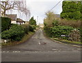
Garne's Lane, Fulbrook
From the north side of the A361, Garne's Lane leads to Dolphin Lane and the church of St James the Great.
Image: © Jaggery
Taken: 16 Jan 2018
0.05 miles
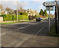
9
Grass triangle at a junction in Fulbrook, West Oxfordshire
A361 on the left, Westhall Hill https://www.geograph.org.uk/photo/5655008 on the right.
Image: © Jaggery
Taken: 16 Jan 2018
0.06 miles
10
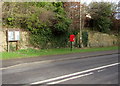
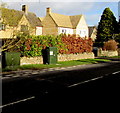
Queen Elizabeth II postbox, Fulbrook, West Oxfordshire
On the north side of the A361 near Church Lane.
Image: © Jaggery
Taken: 16 Jan 2018
0.06 miles