IMAGES TAKEN NEAR TO
Oakfield Road, CARTERTON, OX18 3SW
Introduction
This page details the photographs taken nearby to Oakfield Road, OX18 3SW by members of the Geograph project.
The Geograph project started in 2005 with the aim of publishing, organising and preserving representative images for every square kilometre of Great Britain, Ireland and the Isle of Man.

There are currently over 7.5m images from over14,400 individuals and you can help contribute to the project by visiting https://www.geograph.org.uk
Image Map (Loading...)


Getting Data...Please wait
Leaflet Map data © OpenStreetMap
Images are licensed for reuse under creativecommons.org/licenses/by-sa/2.0
Notes
- Clicking on the map will re-center to the selected point.
- The higher the marker number, the further away the image location is from the centre of the postcode.
Image Listing (14 Images Found)
Images are licensed for reuse under creativecommons.org/licenses/by-sa/2.0
Image
Details
Distance
5
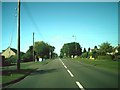
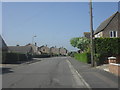
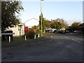
Alvescot Road, Carterton
Heading away from the town centre.
Image: © andrew auger
Taken: 12 Sep 2009
0.16 miles
7
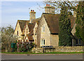
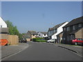
Carterton, Rock Farm Cottages
Rock Farm Cottages are one of the few pre-twentieth century buildings in Carterton. A relic of when the entire area was farmland.
Image: © Martin Loader
Taken: 11 Mar 2007
0.17 miles
8
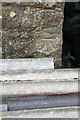
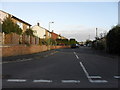
Benchmark on 'Rock Cottage', #1 Lawton Avenue
Ordnance Survey cut mark benchmark described on the Bench Mark Database at http://www.bench-marks.org.uk/bm79885
Image: © Roger Templeman
Taken: 18 Oct 2016
0.17 miles
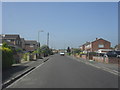
10
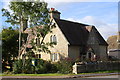
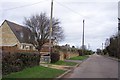
Cottages at junction of Alvescot Road and Lawton Avenue
There is an OS benchmark Image on the near corner on the nearer cottage on its left hand face.
Image: © Roger Templeman
Taken: 18 Oct 2016
0.18 miles