IMAGES TAKEN NEAR TO
Stonelands, CARTERTON, OX18 3PA
Introduction
This page details the photographs taken nearby to Stonelands, OX18 3PA by members of the Geograph project.
The Geograph project started in 2005 with the aim of publishing, organising and preserving representative images for every square kilometre of Great Britain, Ireland and the Isle of Man.

There are currently over 7.5m images from over14,400 individuals and you can help contribute to the project by visiting https://www.geograph.org.uk
Image Map
Images are licensed for reuse under creativecommons.org/licenses/by-sa/2.0
Notes
- Clicking on the map will re-center to the selected point.
- The higher the marker number, the further away the image location is from the centre of the postcode.
Image Listing (14 Images Found)
Images are licensed for reuse under creativecommons.org/licenses/by-sa/2.0
Image
Details
Distance
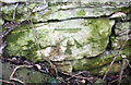
1
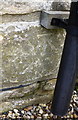
Benchmark on 'Stonelands'
Ordnance Survey cut mark benchmark described on the Bench Mark Database at http://www.bench-marks.org.uk/bm83276
Image: © Roger Templeman
Taken: 24 Mar 2017
0.01 miles
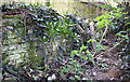
2
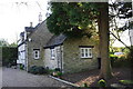
'Stonelands', Burford Road
There is an OS benchmark Image behind the downpipe on the corner of the main section of the house
Image: © Roger Templeman
Taken: 24 Mar 2017
0.01 miles
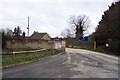
3
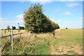
Footpath to Asthall
From the road by Stonelands.
Image: © andrew auger
Taken: 26 Sep 2009
0.05 miles
4
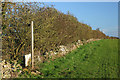
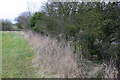
Footpath and hedge, Stonelands
The footpath towards Burford disappears through the hedge at Stonelands.
Image: © Martin Loader
Taken: 9 Dec 2006
0.07 miles
5
Benchmark on wall on west side of Burford Road
Ordnance Survey cut mark benchmark described on the Bench Mark Database at www.bench-marks.org.uk/bm83337
Image: © Roger Templeman
Taken: 24 Mar 2017
0.13 miles
6
Dry stone wall on west side of Burford Road south of the Shilton turn
There is an Ordnance Survey benchmark Image on a stone in the wall in the left foreground
Image: © Roger Templeman
Taken: 24 Mar 2017
0.13 miles
7
Burford quarry entrance
Closed on Saturday afternoon.
Image: © andrew auger
Taken: 5 Dec 2009
0.15 miles
8
Bekstone Quarry
The stone from this quarry is crushed and reformed into 'Cotswold' looking blocks for the modern building market.
Image: © Jonathan Billinger
Taken: 14 Dec 2006
0.15 miles
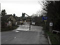
9
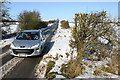
Road near Stonelands
The road from the A40 towards Stonelands and Brize Norton is relatively free of snow after several days of heavy snowfall.
Image: © Martin Loader
Taken: 7 Feb 2009
0.18 miles
10
Dry stone wall between minor road and field
There is an OS benchmark Image on the wooden gatepost at the near end of the dry stone wall
Image: © Roger Templeman
Taken: 20 Feb 2017
0.19 miles