IMAGES TAKEN NEAR TO
Burford Road, CARTERTON, OX18 3NN
Introduction
This page details the photographs taken nearby to Burford Road, OX18 3NN by members of the Geograph project.
The Geograph project started in 2005 with the aim of publishing, organising and preserving representative images for every square kilometre of Great Britain, Ireland and the Isle of Man.

There are currently over 7.5m images from over14,400 individuals and you can help contribute to the project by visiting https://www.geograph.org.uk
Image Map (Loading...)


Getting Data...Please wait
Leaflet Map data © OpenStreetMap
Images are licensed for reuse under creativecommons.org/licenses/by-sa/2.0
Notes
- Clicking on the map will re-center to the selected point.
- The higher the marker number, the further away the image location is from the centre of the postcode.
Image Listing (13 Images Found)
Images are licensed for reuse under creativecommons.org/licenses/by-sa/2.0
Image
Details
Distance
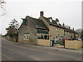
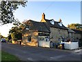
2
Masons Arms (1), Burford Road, Brize Norton, Oxon
Cottage style public house, just out of the main part of the village. At one time it used to be a Bass-Charrington house but it is now a privately owned free house.
Image
Image
Image: © P L Chadwick
Taken: 5 Oct 2017
0.07 miles
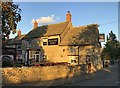
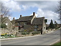
4
Masons Arms (2), Burford Road, Brize Norton, Oxon
Cottage style public house, just out of the main part of the village. At one time it used to be a Bass-Charrington house but it is now a privately owned free house.
Image
Image
Image: © P L Chadwick
Taken: 5 Oct 2017
0.08 miles
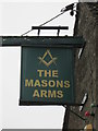
5
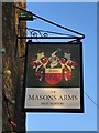
Masons Arms (3) - sign, Burford Road, Brize Norton, Oxon
The sign has changed in the last few years since it was previously photographed for this site.
Image
Image
Image: © P L Chadwick
Taken: 5 Oct 2017
0.08 miles
6
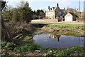
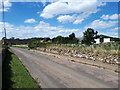
Pond beside Burford Road opposite Brook House
Image: © Roger Templeman
Taken: 24 Mar 2017
0.09 miles
7
Masons Arms, Brize Norton
excellent for the plane spotter
Image: © al partington
Taken: 4 Apr 2006
0.11 miles
8
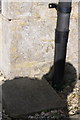
Benchmark on 'Malt House'
Ordnance Survey cut mark benchmark described on the Bench Mark Database at http://www.bench-marks.org.uk/bm83104
Image: © Roger Templeman
Taken: 24 Mar 2017
0.14 miles
9
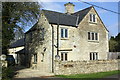
'Malt House', Burford Road
There is an OS benchmark Imageon the near corner, right hand face of the house, left of the downpipe
Image: © Roger Templeman
Taken: 24 Mar 2017
0.14 miles