IMAGES TAKEN NEAR TO
Bourton Close, BAMPTON, OX18 2RU
Introduction
This page details the photographs taken nearby to Bourton Close, OX18 2RU by members of the Geograph project.
The Geograph project started in 2005 with the aim of publishing, organising and preserving representative images for every square kilometre of Great Britain, Ireland and the Isle of Man.

There are currently over 7.5m images from over14,400 individuals and you can help contribute to the project by visiting https://www.geograph.org.uk
Image Map (Loading...)


Getting Data...Please wait
Leaflet Map data © OpenStreetMap
Images are licensed for reuse under creativecommons.org/licenses/by-sa/2.0
Notes
- Clicking on the map will re-center to the selected point.
- The higher the marker number, the further away the image location is from the centre of the postcode.
Image Listing (44 Images Found)
Images are licensed for reuse under creativecommons.org/licenses/by-sa/2.0
Image
Details
Distance
1
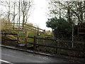
Footpath off the B4020
On the northern edge of Clanfield.
Image: © andrew auger
Taken: 5 Dec 2009
0.01 miles
2
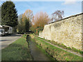
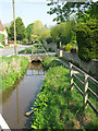
Roadside Stream, Clanfield
This is the Clanfield Brook which runs along beside the main road all the way through the village.
Image: © Des Blenkinsopp
Taken: 22 Feb 2016
0.02 miles
3
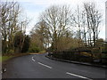
Bends in the B4020
Heading north out of Clanfield.
Image: © andrew auger
Taken: 5 Dec 2009
0.05 miles
4
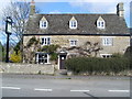
The Clanfield Tavern
Built in 1610 and named "The Masons Arms", it is situated in Bampton Road, Clanfield. Its postcode is OX18 2RG.
Image: © David Hillas
Taken: 4 Apr 2009
0.05 miles
5
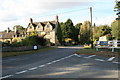
Junction in the middle of Clanfield
Where the A4095 from Bampton turns right towards Faringdon. The road in the picture is the B4020 to Black Bourton, Alvescot,Carterton, and as on the sign, RAF Brize Norton. The building is the Plough.
Image: © andrew auger
Taken: 4 Oct 2009
0.05 miles
7
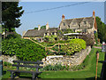
The Cotswold Plough, Bourton Road
Grade II listed, the Plough was built in the mid- to late-17th century, originally as a wool merchant's house; it became a coaching inn, and is now a hotel & restaurant. https://historicengland.org.uk/listing/the-list/list-entry/1198933
Image: © Vieve Forward
Taken: 9 Aug 2020
0.05 miles
8
Stream alongside Bourton Road, Clanfield
Image: © Nick Smith
Taken: 20 Apr 2011
0.05 miles
9
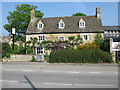
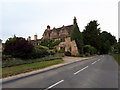
The Clanfield Tavern in the spring sunshine
Image: © Nick Smith
Taken: 20 Apr 2011
0.05 miles