IMAGES TAKEN NEAR TO
Chandler Close, BAMPTON, OX18 2NW
Introduction
This page details the photographs taken nearby to Chandler Close, OX18 2NW by members of the Geograph project.
The Geograph project started in 2005 with the aim of publishing, organising and preserving representative images for every square kilometre of Great Britain, Ireland and the Isle of Man.

There are currently over 7.5m images from over14,400 individuals and you can help contribute to the project by visiting https://www.geograph.org.uk
Image Map
Images are licensed for reuse under creativecommons.org/licenses/by-sa/2.0
Notes
- Clicking on the map will re-center to the selected point.
- The higher the marker number, the further away the image location is from the centre of the postcode.
Image Listing (7 Images Found)
Images are licensed for reuse under creativecommons.org/licenses/by-sa/2.0
Image
Details
Distance
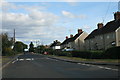
3
Bushey Row, Bampton
Junction with New Road.
Image: © andrew auger
Taken: 4 Oct 2009
0.19 miles
4
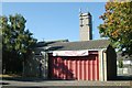
Bampton (Oxfordshire) fire station
Bampton fire station, New Road, Bampton, Oxfordshire
Image: © Kevin Hale
Taken: 5 Oct 2007
0.19 miles

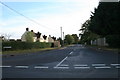
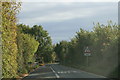
6
New Road, Bampton
Looking west from the eastern end of the road, near the junction with Mount Owen Road.
Image: © andrew auger
Taken: 4 Oct 2009
0.21 miles
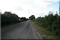
7
Coming into Bampton
From the north on the A4095
Image: © andrew auger
Taken: 4 Oct 2009
0.22 miles