IMAGES TAKEN NEAR TO
Andrews Way, OX18 2GD
Introduction
This page details the photographs taken nearby to Andrews Way, OX18 2GD by members of the Geograph project.
The Geograph project started in 2005 with the aim of publishing, organising and preserving representative images for every square kilometre of Great Britain, Ireland and the Isle of Man.

There are currently over 7.5m images from over14,400 individuals and you can help contribute to the project by visiting https://www.geograph.org.uk
Image Map
Images are licensed for reuse under creativecommons.org/licenses/by-sa/2.0
Notes
- Clicking on the map will re-center to the selected point.
- The higher the marker number, the further away the image location is from the centre of the postcode.
Image Listing (13 Images Found)
Images are licensed for reuse under creativecommons.org/licenses/by-sa/2.0
Image
Details
Distance
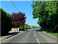
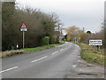
3
Approaching Bampton
On the B4449 from Aston.
Image: © andrew auger
Taken: 3 Oct 2009
0.11 miles
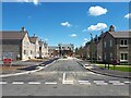
4
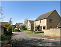
Beam Paddock, Bampton
New housing on the edge of town.
Image: © Des Blenkinsopp
Taken: 15 Apr 2015
0.12 miles
6
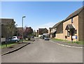
Talbot Fields, Bampton
New housing on the edge of town.
Image: © Des Blenkinsopp
Taken: 15 Apr 2015
0.14 miles
7
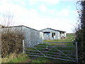
Dilapidated shack
Even the gate is bent here, and the prefab has seen its best days.
Image: © Jonathan Billinger
Taken: 23 Jan 2007
0.14 miles
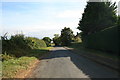
8
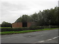
Roadside farm buildings
Beside Aston Road, Bampton, by the junction with Mount Owen Road.
Image: © andrew auger
Taken: 26 Sep 2010
0.17 miles
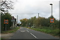
9
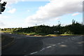
Junction of New Road and Mount Owen Road, Bampton
Image: © andrew auger
Taken: 4 Oct 2009
0.18 miles