IMAGES TAKEN NEAR TO
BAMPTON, OX18 2EW
Introduction
This page details the photographs taken nearby to OX18 2EW by members of the Geograph project.
The Geograph project started in 2005 with the aim of publishing, organising and preserving representative images for every square kilometre of Great Britain, Ireland and the Isle of Man.

There are currently over 7.5m images from over14,400 individuals and you can help contribute to the project by visiting https://www.geograph.org.uk
Image Map
Images are licensed for reuse under creativecommons.org/licenses/by-sa/2.0
Notes
- Clicking on the map will re-center to the selected point.
- The higher the marker number, the further away the image location is from the centre of the postcode.
Image Listing (5 Images Found)
Images are licensed for reuse under creativecommons.org/licenses/by-sa/2.0
Image
Details
Distance
1
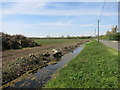
Ditching beside Buckland Road
Around here is all flat land at risk of flooding. Keeping the drainage in good order is important.
Image: © Des Blenkinsopp
Taken: 5 May 2016
0.11 miles
2
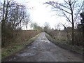
Unnamed track into the marshes
Off the Buckland Road south of Bampton.
Image: © Jonathan Billinger
Taken: 23 Jan 2007
0.14 miles
3
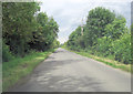
Buckland Road southeast of Hedgefields Farm
Image: © Stuart Logan
Taken: 15 Jul 2012
0.15 miles
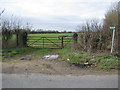
5
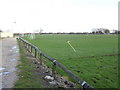
Bampton football ground.
Off Buckland Road.
Image: © Jonathan Billinger
Taken: 23 Jan 2007
0.25 miles