IMAGES TAKEN NEAR TO
Smiths Close, BAMPTON, OX18 2DP
Introduction
This page details the photographs taken nearby to Smiths Close, OX18 2DP by members of the Geograph project.
The Geograph project started in 2005 with the aim of publishing, organising and preserving representative images for every square kilometre of Great Britain, Ireland and the Isle of Man.

There are currently over 7.5m images from over14,400 individuals and you can help contribute to the project by visiting https://www.geograph.org.uk
Image Map (Loading...)


Getting Data...Please wait
Leaflet Map data © OpenStreetMap
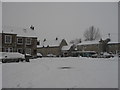
Images are licensed for reuse under creativecommons.org/licenses/by-sa/2.0
Notes
- Clicking on the map will re-center to the selected point.
- The higher the marker number, the further away the image location is from the centre of the postcode.
Image Listing (30 Images Found)
Images are licensed for reuse under creativecommons.org/licenses/by-sa/2.0
Image
Details
Distance
1
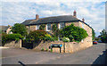
Church Farm House, Bull Street, Aston
Image: © Des Blenkinsopp
Taken: 9 Jun 2014
0.03 miles
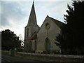
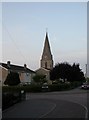
6
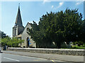
Aston church
St. James's is a grade II listed building, 1839.
Image: © Robin Webster
Taken: 18 May 2014
0.08 miles
7
Aston church
St. James's is a grade II listed building, 1839.
Image: © Robin Webster
Taken: 18 May 2014
0.08 miles
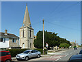
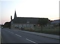
8
Aston, church spire
C19 spire of St. James', on Standlake Road. http://www.imagesofengland.org.uk/Details/Default.aspx?id=252091&mode=adv
Image: © Mike Faherty
Taken: 15 Aug 2010
0.09 miles
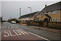
9
Aston, primary school
Aston & Cote C of E Primary School, on Cote Road. http://www.aston-and-cote.oxon.sch.uk/index.htm
Image: © Mike Faherty
Taken: 15 Aug 2010
0.09 miles