IMAGES TAKEN NEAR TO
OX18 1PL
Introduction
This page details the photographs taken nearby to OX18 1PL by members of the Geograph project.
The Geograph project started in 2005 with the aim of publishing, organising and preserving representative images for every square kilometre of Great Britain, Ireland and the Isle of Man.

There are currently over 7.5m images from over14,400 individuals and you can help contribute to the project by visiting https://www.geograph.org.uk
Image Map
Images are licensed for reuse under creativecommons.org/licenses/by-sa/2.0
Notes
- Clicking on the map will re-center to the selected point.
- The higher the marker number, the further away the image location is from the centre of the postcode.
Image Listing (2 Images Found)
Images are licensed for reuse under creativecommons.org/licenses/by-sa/2.0
Image
Details
Distance
1
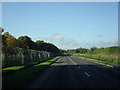
Road from Brize Norton to Carterton
RAF Brize Norton is inside the barbed wire fence on the left.
Image: © andrew auger
Taken: 16 Oct 2010
0.24 miles
2
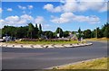
Roundabout in Monahan Way, Carterton, Oxon
This roundabout currently has two floral displays each representing a Union Jack flag. They were originally planted in 2014 as part of the town’s summer displays to mark the centenary of the First World War. Monahan Way is the road behind the roundabout and to the right. The road going off to the left of the roundabout, which is not visible in this view, is Norton Way. Behind the camera position is a car park and a sports centre.
Image
Image: © P L Chadwick
Taken: 9 Aug 2016
0.25 miles