IMAGES TAKEN NEAR TO
Browns Field Way, OX18 1NX
Introduction
This page details the photographs taken nearby to Browns Field Way, OX18 1NX by members of the Geograph project.
The Geograph project started in 2005 with the aim of publishing, organising and preserving representative images for every square kilometre of Great Britain, Ireland and the Isle of Man.

There are currently over 7.5m images from over14,400 individuals and you can help contribute to the project by visiting https://www.geograph.org.uk
Image Map
Images are licensed for reuse under creativecommons.org/licenses/by-sa/2.0
Notes
- Clicking on the map will re-center to the selected point.
- The higher the marker number, the further away the image location is from the centre of the postcode.
Image Listing (11 Images Found)
Images are licensed for reuse under creativecommons.org/licenses/by-sa/2.0
Image
Details
Distance
1
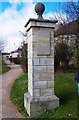
Pillar, Bluebell Way, Shilton Park Estate, Carterton, Oxon
The pillar with its Shilton Park plaque is at the junction of Bluebell Way and Monahan Way. Bluebell Way is one of the vehicular accesses to the Shilton Park Estate.
Image
Image: © P L Chadwick
Taken: 27 Mar 2016
0.11 miles
2
Bluebell Way, Shilton Park, Carterton, Oxon
Viewed from Monahan Way. Bluebell Way is one of the two vehicular accesses to the Shilton Park Estate from Monahan Way.
Image: © P L Chadwick
Taken: 27 Mar 2016
0.12 miles
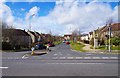
3
Roundabout on Monahan Way, Carterton, Oxon
Branching left from the roundabout is Teasel Way, one of the two vehicular accesses to the Shilton Park Estate from Monahan Way.
Image: © P L Chadwick
Taken: 27 Mar 2016
0.16 miles
4
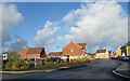
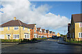
Faulkner Place, Carterton
A new residential street on the edge of Carterton.
Image: © Des Blenkinsopp
Taken: 15 Dec 2020
0.16 miles
5
Wilkins Close, Carterton
A new residential street on the edge of Carterton.
Image: © Des Blenkinsopp
Taken: 15 Dec 2020
0.16 miles
6
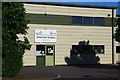
Carterton Veterinary Surgery (1), 12 Ventura Business Park, Broadshires Way, Carterton, Oxon
This practice was established in 2014, Rather unusually it is tucked away on a business park, but the parking is free!
Image
Image: © P L Chadwick
Taken: 29 May 2020
0.18 miles
7

Carterton Veterinary Surgery (2), 12 Ventura Business Park, Broadshires Way, Carterton, Oxon
An independent veterinary practice established in 2014.
Image
Image: © P L Chadwick
Taken: 29 May 2020
0.18 miles
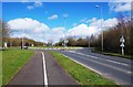
8
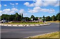
Roundabout in Monahan Way, Carterton, Oxon
This roundabout currently has two floral displays each representing a Union Jack flag. They were originally planted in 2014 as part of the town’s summer displays to mark the centenary of the First World War. Monahan Way is the road behind the roundabout and to the right. The road going off to the left of the roundabout, which is not visible in this view, is Norton Way. Behind the camera position is a car park and a sports centre.
Image
Image: © P L Chadwick
Taken: 9 Aug 2016
0.19 miles
9
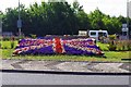
Floral Union Jack, Monahan Way, Carterton, Oxon
One of two floral Union Jack flags planted originally in 2014 in this roundabout. The flowers representing the blue in the flag are more purple than blue. See:- Image
Image: © P L Chadwick
Taken: 9 Aug 2016
0.20 miles
10
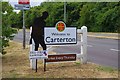
Silent Soldier on B4477, Carterton, Oxon
One of the Royal British Legion's "Silent Soldiers" placed on Monahan Way (B4477) by the town entrance sign. It has been sponsored by Carterton Town Council. The Silent Soldiers are near life-size silhouettes of a First World War "Tommy" cut from black dibond, which is both tough and weatherproof. The Legion's campaign was launched in 2017 in support of the Poppy Appeal to remember the sacrifices made by our Armed Forces during World War I.
Image
Image: © P L Chadwick
Taken: 28 Jul 2018
0.22 miles