IMAGES TAKEN NEAR TO
Magnolia Way, CARTERTON, OX18 1JJ
Introduction
This page details the photographs taken nearby to Magnolia Way, OX18 1JJ by members of the Geograph project.
The Geograph project started in 2005 with the aim of publishing, organising and preserving representative images for every square kilometre of Great Britain, Ireland and the Isle of Man.

There are currently over 7.5m images from over14,400 individuals and you can help contribute to the project by visiting https://www.geograph.org.uk
Image Map (Loading...)


Getting Data...Please wait
Leaflet Map data © OpenStreetMap
Images are licensed for reuse under creativecommons.org/licenses/by-sa/2.0
Notes
- Clicking on the map will re-center to the selected point.
- The higher the marker number, the further away the image location is from the centre of the postcode.
Image Listing (49 Images Found)
Images are licensed for reuse under creativecommons.org/licenses/by-sa/2.0
Image
Details
Distance
1
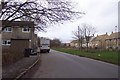
Housing in Carterton
The new meets the older; to the left is a 'sink estate' to the right is newly built modern detached houses. In between is a culvert, and a young plantation of very thorny dense-growing species. When the plants grow into a thick screening hedge, the separation between the two estates should be complete.
Image: © Jonathan Billinger
Taken: 14 Dec 2006
0.08 miles
2
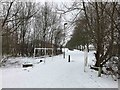
Footpath to Northwood Crescent, Carterton, Oxon
This footpath links the Shilton Park housing estate to Northwood Crescent and nearby sports and medical facilities. The railings are in place because there is actually a bridge here crossing a small stream or watercourse.
Image: © L S Wilson
Taken: 3 Mar 2018
0.09 miles
3
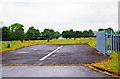
Hardstanding, Raynham Close, Carterton, Oxon
The hardstanding is a spur off the end of Raynham Close. It served a block of garages used by the occupiers of the RAF housing in the close. Both housing and garage block have now gone but the hardstanding now provides access to the electricity substation built on the site of the garages. This is on the right behind the grey railings.
Image
Image: © P L Chadwick
Taken: 13 Jun 2015
0.09 miles
4

Marigold Square Co-Op Store
The side entrance to the store in one of the pale coloured buildings which make up most of this recently built neighbourhood. Low key signage and minimum use of tacky posters.
Image: © Des Blenkinsopp
Taken: 15 Dec 2020
0.09 miles
5

Electricity substation, Raynham Close, Carterton, Oxon
On the site of this substation was a block of garages used by the occupiers of the RAF housing in Raynham Close. The garages and the housing were demolished about 2011.
Image
Image
Image: © P L Chadwick
Taken: 13 Jun 2015
0.10 miles
6
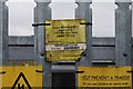
Sign on electricity substation, Raynham Close, Carterton, Oxon
Sign with emergency number on the railings surrounding the sub-station.
Image
Image: © P L Chadwick
Taken: 13 Jun 2015
0.10 miles
7
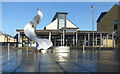
Marigold Square, Carterton
With Carterton Community Centre which opened in 2008. http://www.cartertoncommunitycentre.com
Sculpture by Richard Thornton.
Image: © Des Blenkinsopp
Taken: 15 Dec 2020
0.10 miles
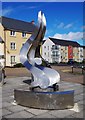
8
Sculpture in Marigold Square (2), Shilton Park, Carterton, Oxon
For details please see:- Image
Image: © P L Chadwick
Taken: 27 Mar 2016
0.10 miles
9
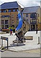
Sculpture in Marigold Square (1), Shilton Park, Carterton, Oxon
This sculpture has been erected just outside the community centre. It was commissioned by West Oxfordshire District Council "to celebrate and give a sense of place to this new major development". Made of stasinless steel and five metres high, the council commissioned the work from Richard Thornton Sculpture.
Image
Image: © P L Chadwick
Taken: 27 Mar 2016
0.10 miles
10
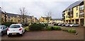
Marigold Square, Shilton Park, Carterton, Oxon
A view of part of the large Marigold Square. It serves as the focal point for the Shilton Park Estate, on the northern side of the town. The square includes a few shops, including a Co-op convenience store, and other businesses. Carterton Community Centre is also here, although it cannot be seen in this view. Most of the square, however, consists of residential apartments.
Image: © P L Chadwick
Taken: 31 Jan 2016
0.10 miles